You are here: Home > Network List > TA - USArray Transportable Network (new EarthScope stations) Stations List
> Station Z51A Franklin, GA, USA > Earthquake Result Viewer
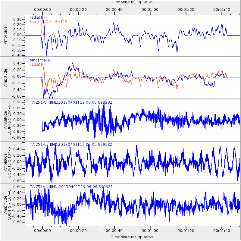
Z51A Franklin, GA, USA - Earthquake Result Viewer
*The percent match for this event was below the threshold and hence no stack was calculated.
| Earthquake location: |
Off East Coast Of Honshu, Japan |
| Earthquake latitude/longitude: |
39.5/143.2 |
| Earthquake time(UTC): |
2013/04/01 (091) 18:53:17 GMT |
| Earthquake Depth: |
14 km |
| Earthquake Magnitude: |
6.0 MW, 5.6 MB, 5.7 MS, 6.0 MW |
| Earthquake Catalog/Contributor: |
NEIC PDE/NEIC PDE-W |
|
| Network: |
TA USArray Transportable Network (new EarthScope stations) |
| Station: |
Z51A Franklin, GA, USA |
| Lat/Lon: |
33.32 N/85.17 W |
| Elevation: |
249 m |
|
| Distance: |
94.8 deg |
| Az: |
38.888 deg |
| Baz: |
324.557 deg |
| Ray Param: |
$rayparam |
*The percent match for this event was below the threshold and hence was not used in the summary stack. |
|
| Radial Match: |
43.714626 % |
| Radial Bump: |
400 |
| Transverse Match: |
36.01763 % |
| Transverse Bump: |
400 |
| SOD ConfigId: |
510825 |
| Insert Time: |
2013-09-04 22:23:36.109 +0000 |
| GWidth: |
2.5 |
| Max Bumps: |
400 |
| Tol: |
0.001 |
|
Signal To Noise
| Channel | StoN | STA | LTA |
| TA:Z51A: :BHZ:20130401T19:06:06.89998Z | 1.2699238 | 2.3344825E-7 | 1.8382856E-7 |
| TA:Z51A: :BHN:20130401T19:06:06.89998Z | 1.3859249 | 3.1352764E-7 | 2.2622268E-7 |
| TA:Z51A: :BHE:20130401T19:06:06.89998Z | 2.184686 | 4.477657E-7 | 2.0495655E-7 |
| Arrivals |
| Ps | |
| PpPs | |
| PsPs/PpSs | |


