You are here: Home > Network List > GT - Global Telemetered Seismograph Network (USAF/USGS) Stations List
> Station PLCA Paso Flores, Argentina > Earthquake Result Viewer
PLCA Paso Flores, Argentina - Earthquake Result Viewer

| Earthquake location: |
Northern Peru |
| Earthquake latitude/longitude: |
-4.4/-76.7 |
| Earthquake time(UTC): |
1997/10/28 (301) 06:15:17 GMT |
| Earthquake Depth: |
112 km |
| Earthquake Magnitude: |
6.6 MB, 6.3 MS, 7.2 UNKNOWN, 6.6 ME |
| Earthquake Catalog/Contributor: |
WHDF/NEIC |
|
| Network: |
GT Global Telemetered Seismograph Network (USAF/USGS) |
| Station: |
PLCA Paso Flores, Argentina |
| Lat/Lon: |
40.73 S/70.55 W |
| Elevation: |
1050 m |
|
| Distance: |
36.6 deg |
| Az: |
172.181 deg |
| Baz: |
349.718 deg |
| Ray Param: |
0.07621204 |
| Estimated Moho Depth: |
35.25 km |
| Estimated Crust Vp/Vs: |
1.80 |
| Assumed Crust Vp: |
6.597 km/s |
| Estimated Crust Vs: |
3.67 km/s |
| Estimated Crust Poisson's Ratio: |
0.28 |
|
| Radial Match: |
95.66297 % |
| Radial Bump: |
355 |
| Transverse Match: |
87.70808 % |
| Transverse Bump: |
400 |
| SOD ConfigId: |
6273 |
| Insert Time: |
2010-02-27 02:14:01.966 +0000 |
| GWidth: |
2.5 |
| Max Bumps: |
400 |
| Tol: |
0.001 |
|
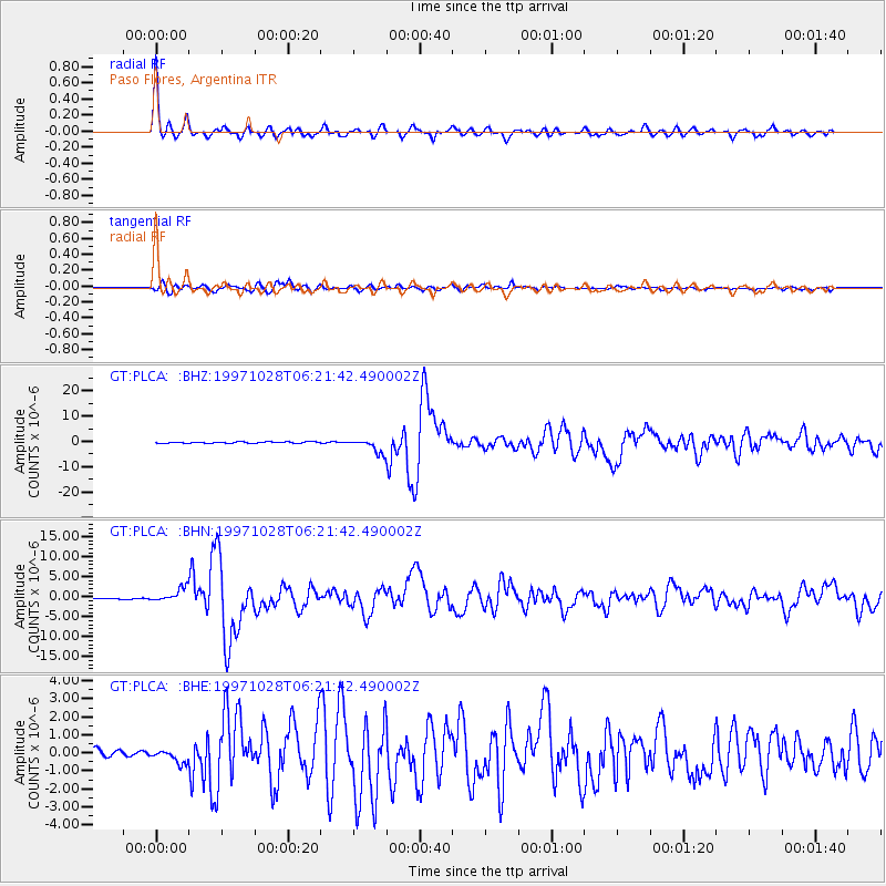
Signal To Noise
| Channel | StoN | STA | LTA |
| GT:PLCA: :BHN:19971028T06:21:42.490002Z | 10.230165 | 1.7503596E-6 | 1.710979E-7 |
| GT:PLCA: :BHE:19971028T06:21:42.490002Z | 2.0361013 | 3.5939436E-7 | 1.7651105E-7 |
| GT:PLCA: :BHZ:19971028T06:21:42.490002Z | 9.440923 | 2.722415E-6 | 2.8836322E-7 |
| Arrivals |
| Ps | 4.6 SECOND |
| PpPs | 14 SECOND |
| PsPs/PpSs | 18 SECOND |


