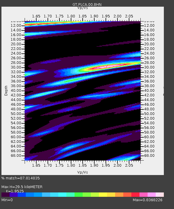
PLCA Paso Flores, Argentina - Earthquake Result Viewer
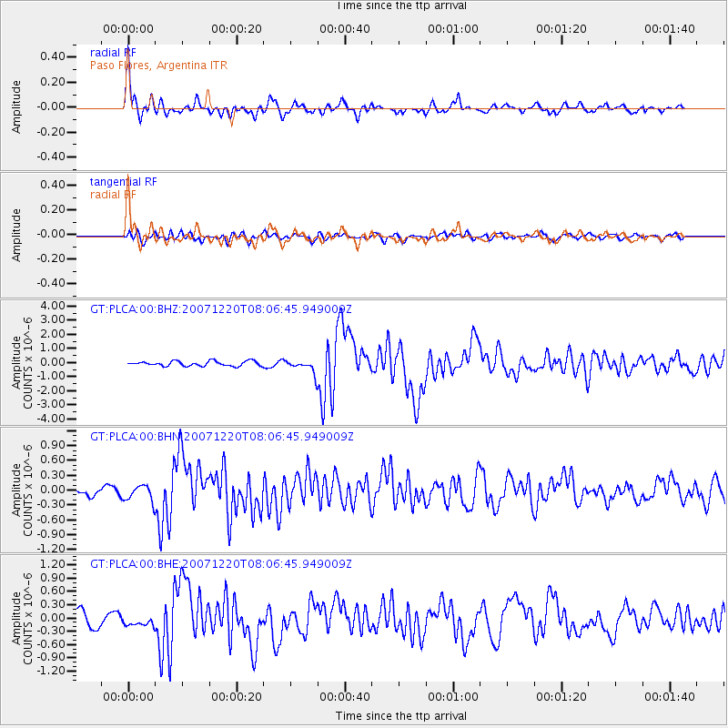
Earthquake location: Off E. Coast Of N. Island, N.Z.
Earthquake latitude/longitude: -39.0/178.3
Earthquake time(UTC): 2007/12/20 (354) 07:55:15 GMT
Earthquake Depth: 20 km
Earthquake Magnitude: 6.3 MB, 6.5 MS, 6.6 MW, 6.5 MW
Earthquake Catalog/Contributor: WHDF/NEIC
Network: GT Global Telemetered Seismograph Network (USAF/USGS)
Station: PLCA Paso Flores, Argentina
Lat/Lon: 40.73 S/70.55 W
Elevation: 1050 m
Distance: 78.8 deg
Az: 133.748 deg
Baz: 227.783 deg
Ray Param: 0.049360868
Estimated Moho Depth: 29.5 km
Estimated Crust Vp/Vs: 1.95
Assumed Crust Vp: 6.597 km/s
Estimated Crust Vs: 3.379 km/s
Estimated Crust Poisson's Ratio: 0.32
Radial Match: 87.814835 %
Radial Bump: 372
Transverse Match: 73.66269 %
Transverse Bump: 400
SOD ConfigId: 2564
Insert Time: 2010-02-27 02:14:03.817 +0000
GWidth: 2.5
Max Bumps: 400
Tol: 0.001

Signal To Noise

ChannelStoNSTALTA
GT:PLCA:00:BHN:20071220T08:06:45.949009Z2.13565681.6347967E-77.654772E-8
GT:PLCA:00:BHE:20071220T08:06:45.949009Z0.645307541.0461915E-71.6212293E-7
GT:PLCA:00:BHZ:20071220T08:06:45.949009Z2.8247594.818197E-71.705702E-7
Arrivals
Ps4.4 SECOND
PpPs13 SECOND
PsPs/PpSs17 SECOND