You are here: Home > Network List > UW - Pacific Northwest Regional Seismic Network Stations List
> Station UMAT Pilot Rock, OR, USA > Earthquake Result Viewer
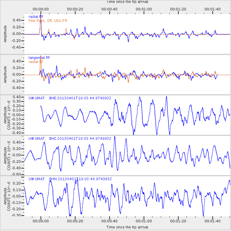
UMAT Pilot Rock, OR, USA - Earthquake Result Viewer
*The percent match for this event was below the threshold and hence no stack was calculated.
| Earthquake location: |
Off East Coast Of Honshu, Japan |
| Earthquake latitude/longitude: |
39.5/143.2 |
| Earthquake time(UTC): |
2013/04/01 (091) 18:53:17 GMT |
| Earthquake Depth: |
14 km |
| Earthquake Magnitude: |
6.0 MW, 5.6 MB, 5.7 MS, 6.0 MW |
| Earthquake Catalog/Contributor: |
NEIC PDE/NEIC PDE-W |
|
| Network: |
UW Pacific Northwest Regional Seismic Network |
| Station: |
UMAT Pilot Rock, OR, USA |
| Lat/Lon: |
45.29 N/118.96 W |
| Elevation: |
1318 m |
|
| Distance: |
68.0 deg |
| Az: |
48.94 deg |
| Baz: |
304.294 deg |
| Ray Param: |
$rayparam |
*The percent match for this event was below the threshold and hence was not used in the summary stack. |
|
| Radial Match: |
73.22051 % |
| Radial Bump: |
375 |
| Transverse Match: |
68.22738 % |
| Transverse Bump: |
365 |
| SOD ConfigId: |
510825 |
| Insert Time: |
2013-09-04 22:27:42.940 +0000 |
| GWidth: |
2.5 |
| Max Bumps: |
400 |
| Tol: |
0.001 |
|
Signal To Noise
| Channel | StoN | STA | LTA |
| UW:UMAT: :BHZ:20130401T19:03:44.974993Z | 2.0574586 | 2.2898618E-7 | 1.1129564E-7 |
| UW:UMAT: :BHN:20130401T19:03:44.974993Z | 0.6993278 | 1.1140681E-7 | 1.5930557E-7 |
| UW:UMAT: :BHE:20130401T19:03:44.974993Z | 0.98773456 | 9.8196935E-8 | 9.9416326E-8 |
| Arrivals |
| Ps | |
| PpPs | |
| PsPs/PpSs | |


