You are here: Home > Network List > GT - Global Telemetered Seismograph Network (USAF/USGS) Stations List
> Station PLCA Paso Flores, Argentina > Earthquake Result Viewer
PLCA Paso Flores, Argentina - Earthquake Result Viewer
| Earthquake location: |
Samoa Islands Region |
| Earthquake latitude/longitude: |
-15.5/-172.1 |
| Earthquake time(UTC): |
2009/09/29 (272) 17:48:10 GMT |
| Earthquake Depth: |
18 km |
| Earthquake Magnitude: |
7.1 MB, 8.1 MS, 8.1 MW, 8.0 MW |
| Earthquake Catalog/Contributor: |
WHDF/NEIC |
|
| Network: |
GT Global Telemetered Seismograph Network (USAF/USGS) |
| Station: |
PLCA Paso Flores, Argentina |
| Lat/Lon: |
40.73 S/70.55 W |
| Elevation: |
1050 m |
|
| Distance: |
88.5 deg |
| Az: |
131.858 deg |
| Baz: |
250.901 deg |
| Ray Param: |
0.04251433 |
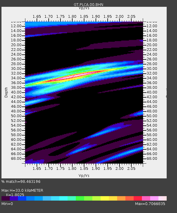
| Estimated Moho Depth: |
33.0 km |
| Estimated Crust Vp/Vs: |
1.80 |
| Assumed Crust Vp: |
6.597 km/s |
| Estimated Crust Vs: |
3.66 km/s |
| Estimated Crust Poisson's Ratio: |
0.28 |
|
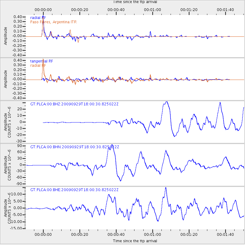
| Radial Match: |
98.463196 % |
| Radial Bump: |
322 |
| Transverse Match: |
92.50172 % |
| Transverse Bump: |
400 |
| SOD ConfigId: |
2622 |
| Insert Time: |
2010-02-27 02:14:20.443 +0000 |
| GWidth: |
2.5 |
| Max Bumps: |
400 |
| Tol: |
0.001 |
|
Signal To Noise
| Channel | StoN | STA | LTA |
| GT:PLCA:00:BHN:20090929T18:00:30.825022Z | 2.488355 | 1.1567452E-6 | 4.648634E-7 |
| GT:PLCA:00:BHE:20090929T18:00:30.825022Z | 1.5699377 | 3.5574402E-7 | 2.2659754E-7 |
| GT:PLCA:00:BHZ:20090929T18:00:30.825022Z | 1.3237922 | 3.4433995E-7 | 2.601163E-7 |
| Arrivals |
| Ps | 4.1 SECOND |
| PpPs | 14 SECOND |
| PsPs/PpSs | 18 SECOND |


