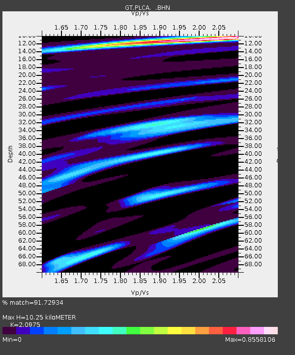
PLCA Paso Flores, Argentina - Earthquake Result Viewer
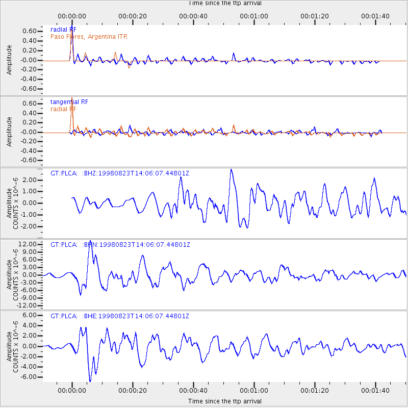
Earthquake location: Off Coast Of Central America
Earthquake latitude/longitude: 11.7/-88.0
Earthquake time(UTC): 1998/08/23 (235) 13:57:15 GMT
Earthquake Depth: 55 km
Earthquake Magnitude: 5.7 MB, 6.3 MS, 6.8 UNKNOWN, 6.7 MW
Earthquake Catalog/Contributor: WHDF/NEIC
Network: GT Global Telemetered Seismograph Network (USAF/USGS)
Station: PLCA Paso Flores, Argentina
Lat/Lon: 40.73 S/70.55 W
Elevation: 1050 m
Distance: 54.6 deg
Az: 163.729 deg
Baz: 338.827 deg
Ray Param: 0.06521781
Estimated Moho Depth: 10.25 km
Estimated Crust Vp/Vs: 2.10
Assumed Crust Vp: 6.597 km/s
Estimated Crust Vs: 3.145 km/s
Estimated Crust Poisson's Ratio: 0.35
Radial Match: 91.72934 %
Radial Bump: 342
Transverse Match: 77.78481 %
Transverse Bump: 400
SOD ConfigId: 4480
Insert Time: 2010-02-27 02:14:24.244 +0000
GWidth: 2.5
Max Bumps: 400
Tol: 0.001

Signal To Noise

ChannelStoNSTALTA
GT:PLCA: :BHN:19980823T14:06:07.44801Z10.2858773.5004987E-63.4032087E-7
GT:PLCA: :BHE:19980823T14:06:07.44801Z7.56233932.0372922E-62.6939972E-7
GT:PLCA: :BHZ:19980823T14:06:07.44801Z1.64707426.128789E-73.7210157E-7
Arrivals
Ps1.8 SECOND
PpPs4.6 SECOND
PsPs/PpSs6.4 SECOND