You are here: Home > Network List > CI - Caltech Regional Seismic Network Stations List
> Station SLA SLA, Trona, CA, USA > Earthquake Result Viewer
SLA SLA, Trona, CA, USA - Earthquake Result Viewer
| Earthquake location: |
Kodiak Island Region, Alaska |
| Earthquake latitude/longitude: |
57.1/-153.2 |
| Earthquake time(UTC): |
2001/01/10 (010) 16:02:44 GMT |
| Earthquake Depth: |
33 km |
| Earthquake Magnitude: |
6.2 MB, 6.8 MS, 7.1 MW, 6.8 ML |
| Earthquake Catalog/Contributor: |
WHDF/NEIC |
|
| Network: |
CI Caltech Regional Seismic Network |
| Station: |
SLA SLA, Trona, CA, USA |
| Lat/Lon: |
35.89 N/117.28 W |
| Elevation: |
1174 m |
|
| Distance: |
32.0 deg |
| Az: |
115.974 deg |
| Baz: |
322.802 deg |
| Ray Param: |
0.07878647 |
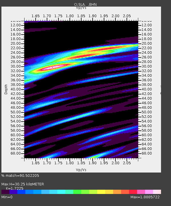
| Estimated Moho Depth: |
30.25 km |
| Estimated Crust Vp/Vs: |
1.72 |
| Assumed Crust Vp: |
6.276 km/s |
| Estimated Crust Vs: |
3.643 km/s |
| Estimated Crust Poisson's Ratio: |
0.25 |
|
| Radial Match: |
90.502205 % |
| Radial Bump: |
387 |
| Transverse Match: |
70.05706 % |
| Transverse Bump: |
400 |
| SOD ConfigId: |
3787 |
| Insert Time: |
2010-02-25 20:29:05.252 +0000 |
| GWidth: |
2.5 |
| Max Bumps: |
400 |
| Tol: |
0.001 |
|
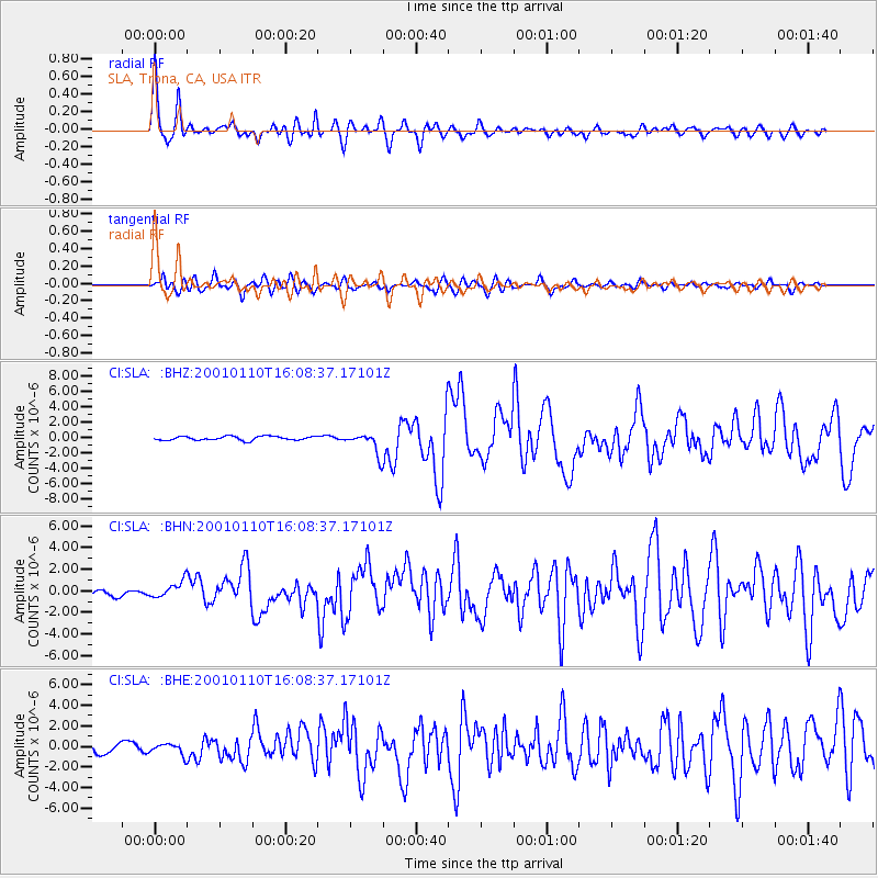
Signal To Noise
| Channel | StoN | STA | LTA |
| CI:SLA: :BHN:20010110T16:08:37.17101Z | 2.3069348 | 7.6783203E-7 | 3.3283646E-7 |
| CI:SLA: :BHE:20010110T16:08:37.17101Z | 0.60634935 | 5.3513395E-7 | 8.825505E-7 |
| CI:SLA: :BHZ:20010110T16:08:37.17101Z | 5.5188713 | 1.3971695E-6 | 2.5316217E-7 |
| Arrivals |
| Ps | 3.8 SECOND |
| PpPs | 12 SECOND |
| PsPs/PpSs | 16 SECOND |


