You are here: Home > Network List > GT - Global Telemetered Seismograph Network (USAF/USGS) Stations List
> Station PLCA Paso Flores, Argentina > Earthquake Result Viewer
PLCA Paso Flores, Argentina - Earthquake Result Viewer

| Earthquake location: |
East Of South Sandwich Islands |
| Earthquake latitude/longitude: |
-60.1/-18.8 |
| Earthquake time(UTC): |
2008/12/14 (349) 20:36:29 GMT |
| Earthquake Depth: |
10 km |
| Earthquake Magnitude: |
5.5 MW, 5.2 MS, 5.3 MB |
| Earthquake Catalog/Contributor: |
WHDF/NEIC |
|
| Network: |
GT Global Telemetered Seismograph Network (USAF/USGS) |
| Station: |
PLCA Paso Flores, Argentina |
| Lat/Lon: |
40.73 S/70.55 W |
| Elevation: |
1050 m |
|
| Distance: |
37.1 deg |
| Az: |
277.71 deg |
| Baz: |
139.174 deg |
| Ray Param: |
0.07634586 |
| Estimated Moho Depth: |
11.5 km |
| Estimated Crust Vp/Vs: |
2.07 |
| Assumed Crust Vp: |
6.597 km/s |
| Estimated Crust Vs: |
3.187 km/s |
| Estimated Crust Poisson's Ratio: |
0.35 |
|
| Radial Match: |
85.19822 % |
| Radial Bump: |
200 |
| Transverse Match: |
52.24607 % |
| Transverse Bump: |
400 |
| SOD ConfigId: |
2658 |
| Insert Time: |
2010-02-27 02:14:27.985 +0000 |
| GWidth: |
2.5 |
| Max Bumps: |
400 |
| Tol: |
0.001 |
|
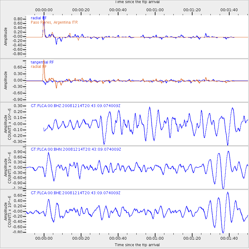
Signal To Noise
| Channel | StoN | STA | LTA |
| GT:PLCA:00:BHN:20081214T20:43:09.074009Z | 7.627594 | 4.3000188E-7 | 5.637451E-8 |
| GT:PLCA:00:BHE:20081214T20:43:09.074009Z | 3.4728377 | 2.3612105E-7 | 6.799082E-8 |
| GT:PLCA:00:BHZ:20081214T20:43:09.074009Z | 3.0939217 | 1.5555298E-7 | 5.0276963E-8 |
| Arrivals |
| Ps | 2.0 SECOND |
| PpPs | 5.0 SECOND |
| PsPs/PpSs | 7.0 SECOND |


