You are here: Home > Network List > GT - Global Telemetered Seismograph Network (USAF/USGS) Stations List
> Station PLCA Paso Flores, Argentina > Earthquake Result Viewer
PLCA Paso Flores, Argentina - Earthquake Result Viewer

| Earthquake location: |
Samoa Islands Region |
| Earthquake latitude/longitude: |
-16.6/-172.0 |
| Earthquake time(UTC): |
2006/09/28 (271) 06:22:09 GMT |
| Earthquake Depth: |
28 km |
| Earthquake Magnitude: |
6.5 MB, 6.6 MS, 6.9 MW, 6.7 MW |
| Earthquake Catalog/Contributor: |
WHDF/NEIC |
|
| Network: |
GT Global Telemetered Seismograph Network (USAF/USGS) |
| Station: |
PLCA Paso Flores, Argentina |
| Lat/Lon: |
40.73 S/70.55 W |
| Elevation: |
1050 m |
|
| Distance: |
87.7 deg |
| Az: |
131.816 deg |
| Baz: |
250.123 deg |
| Ray Param: |
0.043071765 |
| Estimated Moho Depth: |
30.5 km |
| Estimated Crust Vp/Vs: |
1.89 |
| Assumed Crust Vp: |
6.597 km/s |
| Estimated Crust Vs: |
3.486 km/s |
| Estimated Crust Poisson's Ratio: |
0.31 |
|
| Radial Match: |
94.868454 % |
| Radial Bump: |
232 |
| Transverse Match: |
80.96088 % |
| Transverse Bump: |
397 |
| SOD ConfigId: |
2665 |
| Insert Time: |
2010-02-27 02:14:33.463 +0000 |
| GWidth: |
2.5 |
| Max Bumps: |
400 |
| Tol: |
0.001 |
|
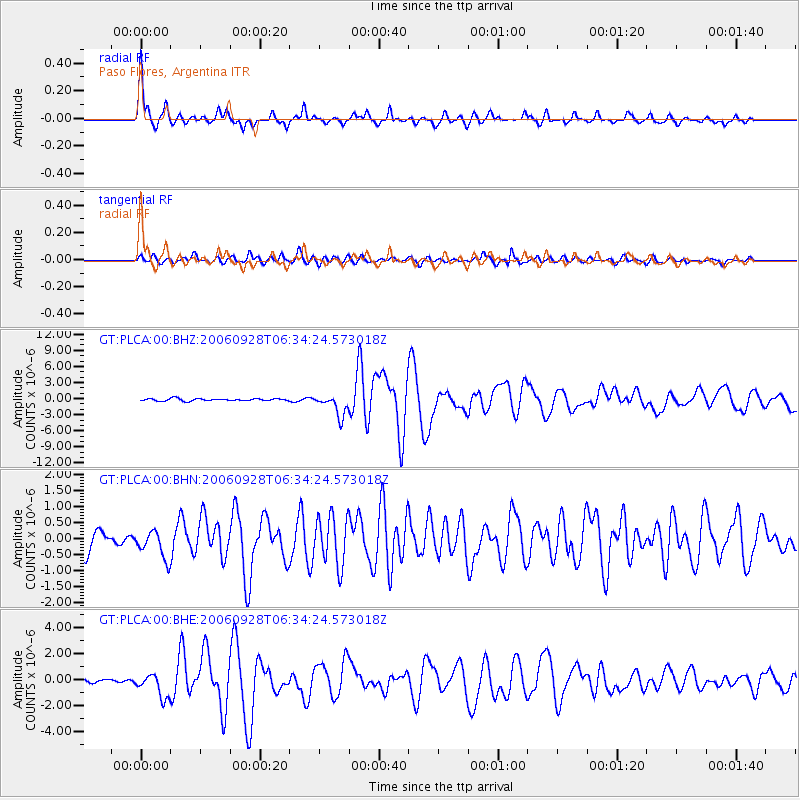
Signal To Noise
| Channel | StoN | STA | LTA |
| GT:PLCA:00:BHN:20060928T06:34:24.573018Z | 1.3734965 | 4.3466986E-7 | 3.1646957E-7 |
| GT:PLCA:00:BHE:20060928T06:34:24.573018Z | 4.3323345 | 9.0455967E-7 | 2.0879266E-7 |
| GT:PLCA:00:BHZ:20060928T06:34:24.573018Z | 9.363268 | 2.0272691E-6 | 2.16513E-7 |
| Arrivals |
| Ps | 4.2 SECOND |
| PpPs | 13 SECOND |
| PsPs/PpSs | 17 SECOND |


