You are here: Home > Network List > GT - Global Telemetered Seismograph Network (USAF/USGS) Stations List
> Station PLCA Paso Flores, Argentina > Earthquake Result Viewer
PLCA Paso Flores, Argentina - Earthquake Result Viewer
| Earthquake location: |
Kermadec Islands Region |
| Earthquake latitude/longitude: |
-31.8/-179.3 |
| Earthquake time(UTC): |
2006/05/16 (136) 10:39:23 GMT |
| Earthquake Depth: |
152 km |
| Earthquake Magnitude: |
6.8 MB, 7.4 MW, 7.4 MW |
| Earthquake Catalog/Contributor: |
WHDF/NEIC |
|
| Network: |
GT Global Telemetered Seismograph Network (USAF/USGS) |
| Station: |
PLCA Paso Flores, Argentina |
| Lat/Lon: |
40.73 S/70.55 W |
| Elevation: |
1050 m |
|
| Distance: |
82.4 deg |
| Az: |
133.453 deg |
| Baz: |
234.447 deg |
| Ray Param: |
0.04657119 |
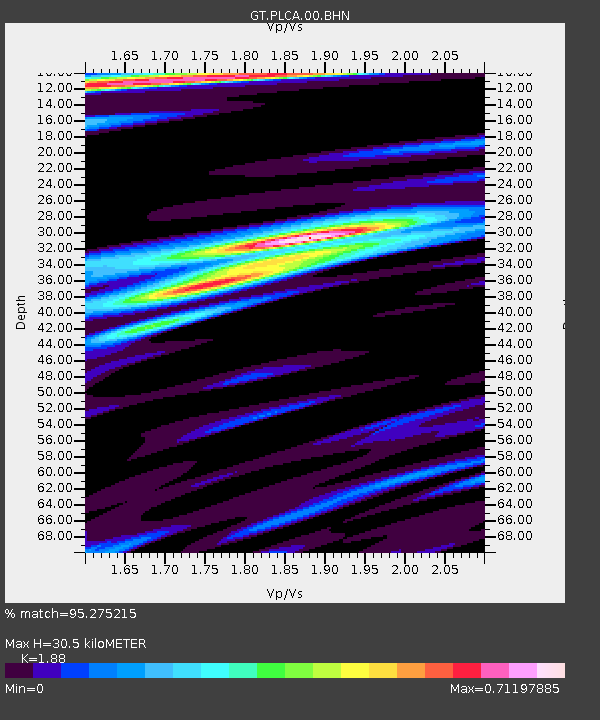
| Estimated Moho Depth: |
30.5 km |
| Estimated Crust Vp/Vs: |
1.88 |
| Assumed Crust Vp: |
6.597 km/s |
| Estimated Crust Vs: |
3.509 km/s |
| Estimated Crust Poisson's Ratio: |
0.30 |
|
| Radial Match: |
95.275215 % |
| Radial Bump: |
354 |
| Transverse Match: |
83.160385 % |
| Transverse Bump: |
400 |
| SOD ConfigId: |
2669 |
| Insert Time: |
2010-02-27 02:14:35.763 +0000 |
| GWidth: |
2.5 |
| Max Bumps: |
400 |
| Tol: |
0.001 |
|
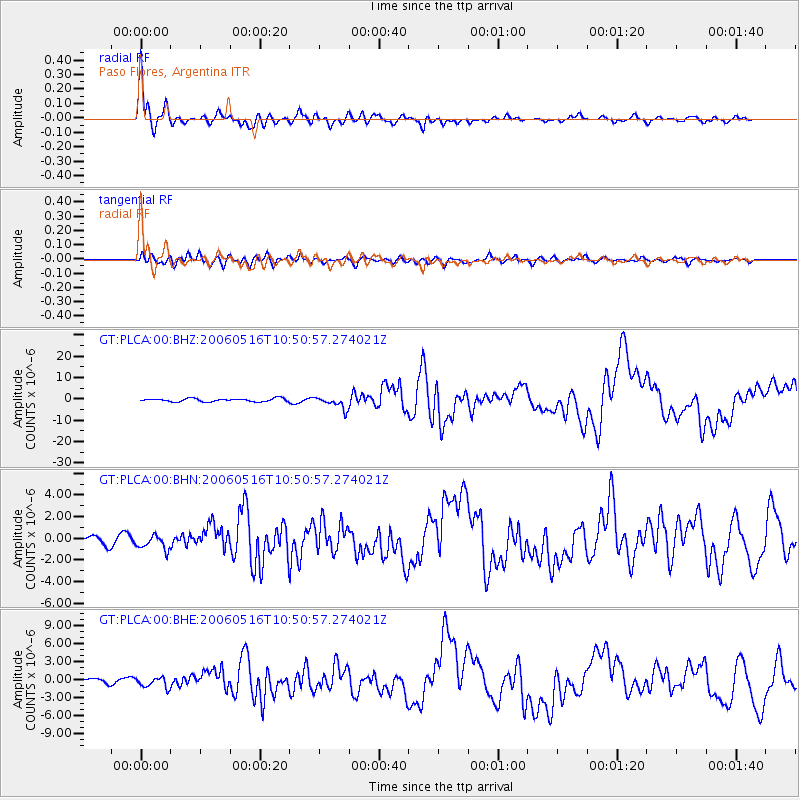
Signal To Noise
| Channel | StoN | STA | LTA |
| GT:PLCA:00:BHN:20060516T10:50:57.274021Z | 2.1100736 | 6.67859E-7 | 3.165098E-7 |
| GT:PLCA:00:BHE:20060516T10:50:57.274021Z | 2.94823 | 8.9837454E-7 | 3.0471656E-7 |
| GT:PLCA:00:BHZ:20060516T10:50:57.274021Z | 3.779074 | 2.8303514E-6 | 7.4895365E-7 |
| Arrivals |
| Ps | 4.2 SECOND |
| PpPs | 13 SECOND |
| PsPs/PpSs | 17 SECOND |


