You are here: Home > Network List > GT - Global Telemetered Seismograph Network (USAF/USGS) Stations List
> Station PLCA Paso Flores, Argentina > Earthquake Result Viewer
PLCA Paso Flores, Argentina - Earthquake Result Viewer
| Earthquake location: |
South Of Fiji Islands |
| Earthquake latitude/longitude: |
-23.6/-180.0 |
| Earthquake time(UTC): |
2006/02/26 (057) 03:08:27 GMT |
| Earthquake Depth: |
535 km |
| Earthquake Magnitude: |
5.9 MB, 6.4 MW, 6.4 MW |
| Earthquake Catalog/Contributor: |
WHDF/NEIC |
|
| Network: |
GT Global Telemetered Seismograph Network (USAF/USGS) |
| Station: |
PLCA Paso Flores, Argentina |
| Lat/Lon: |
40.73 S/70.55 W |
| Elevation: |
1050 m |
|
| Distance: |
88.5 deg |
| Az: |
134.204 deg |
| Baz: |
239.92 deg |
| Ray Param: |
0.041671205 |
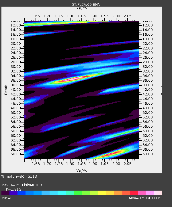
| Estimated Moho Depth: |
35.0 km |
| Estimated Crust Vp/Vs: |
1.82 |
| Assumed Crust Vp: |
6.597 km/s |
| Estimated Crust Vs: |
3.635 km/s |
| Estimated Crust Poisson's Ratio: |
0.28 |
|
| Radial Match: |
80.45113 % |
| Radial Bump: |
300 |
| Transverse Match: |
65.0972 % |
| Transverse Bump: |
331 |
| SOD ConfigId: |
2422 |
| Insert Time: |
2010-02-27 02:14:41.601 +0000 |
| GWidth: |
2.5 |
| Max Bumps: |
400 |
| Tol: |
0.001 |
|
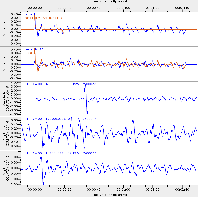
Signal To Noise
| Channel | StoN | STA | LTA |
| GT:PLCA:00:BHN:20060226T03:19:51.750002Z | 1.2420034 | 2.2504851E-7 | 1.8119798E-7 |
| GT:PLCA:00:BHE:20060226T03:19:51.750002Z | 3.203579 | 4.7476743E-7 | 1.4819908E-7 |
| GT:PLCA:00:BHZ:20060226T03:19:51.750002Z | 6.3706408 | 1.3808132E-6 | 2.1674636E-7 |
| Arrivals |
| Ps | 4.4 SECOND |
| PpPs | 15 SECOND |
| PsPs/PpSs | 19 SECOND |


