You are here: Home > Network List > TA - USArray Transportable Network (new EarthScope stations) Stations List
> Station 356A Blackshear, GA, USA > Earthquake Result Viewer
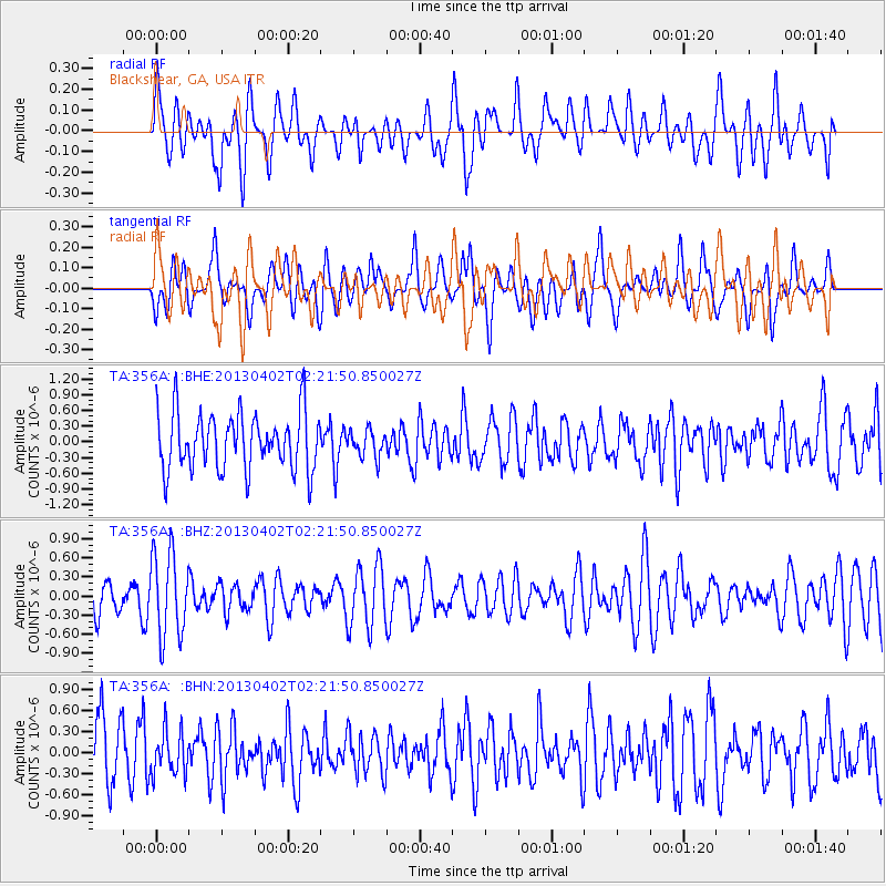
356A Blackshear, GA, USA - Earthquake Result Viewer
*The percent match for this event was below the threshold and hence no stack was calculated.
| Earthquake location: |
Off East Coast Of Honshu, Japan |
| Earthquake latitude/longitude: |
39.5/143.2 |
| Earthquake time(UTC): |
2013/04/02 (092) 02:08:47 GMT |
| Earthquake Depth: |
17 km |
| Earthquake Magnitude: |
5.5 MW, 5.5 MW |
| Earthquake Catalog/Contributor: |
NEIC PDE/NEIC PDE-W |
|
| Network: |
TA USArray Transportable Network (new EarthScope stations) |
| Station: |
356A Blackshear, GA, USA |
| Lat/Lon: |
31.32 N/82.13 W |
| Elevation: |
36 m |
|
| Distance: |
97.9 deg |
| Az: |
37.878 deg |
| Baz: |
326.285 deg |
| Ray Param: |
$rayparam |
*The percent match for this event was below the threshold and hence was not used in the summary stack. |
|
| Radial Match: |
56.430164 % |
| Radial Bump: |
400 |
| Transverse Match: |
46.785137 % |
| Transverse Bump: |
400 |
| SOD ConfigId: |
511491 |
| Insert Time: |
2013-09-05 01:35:15.397 +0000 |
| GWidth: |
2.5 |
| Max Bumps: |
400 |
| Tol: |
0.001 |
|
Signal To Noise
| Channel | StoN | STA | LTA |
| TA:356A: :BHZ:20130402T02:21:50.850027Z | 2.9868758 | 6.611007E-7 | 2.2133518E-7 |
| TA:356A: :BHN:20130402T02:21:50.850027Z | 0.72817916 | 3.0671788E-7 | 4.2121212E-7 |
| TA:356A: :BHE:20130402T02:21:50.850027Z | 0.47010985 | 2.5562855E-7 | 5.437634E-7 |
| Arrivals |
| Ps | |
| PpPs | |
| PsPs/PpSs | |


