You are here: Home > Network List > GT - Global Telemetered Seismograph Network (USAF/USGS) Stations List
> Station PLCA Paso Flores, Argentina > Earthquake Result Viewer
PLCA Paso Flores, Argentina - Earthquake Result Viewer
| Earthquake location: |
Mozambique |
| Earthquake latitude/longitude: |
-21.3/33.6 |
| Earthquake time(UTC): |
2006/02/22 (053) 22:19:07 GMT |
| Earthquake Depth: |
11 km |
| Earthquake Magnitude: |
6.5 MB, 7.5 MS, 7.0 MW, 7.0 MW |
| Earthquake Catalog/Contributor: |
WHDF/NEIC |
|
| Network: |
GT Global Telemetered Seismograph Network (USAF/USGS) |
| Station: |
PLCA Paso Flores, Argentina |
| Lat/Lon: |
40.73 S/70.55 W |
| Elevation: |
1050 m |
|
| Distance: |
86.4 deg |
| Az: |
227.59 deg |
| Baz: |
115.058 deg |
| Ray Param: |
0.044044457 |
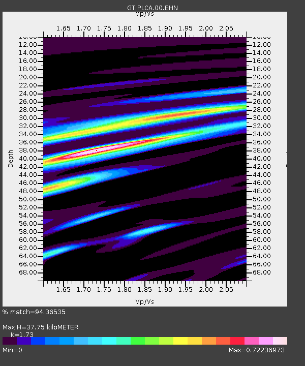
| Estimated Moho Depth: |
37.75 km |
| Estimated Crust Vp/Vs: |
1.73 |
| Assumed Crust Vp: |
6.597 km/s |
| Estimated Crust Vs: |
3.814 km/s |
| Estimated Crust Poisson's Ratio: |
0.25 |
|
| Radial Match: |
94.36535 % |
| Radial Bump: |
400 |
| Transverse Match: |
86.22834 % |
| Transverse Bump: |
400 |
| SOD ConfigId: |
2422 |
| Insert Time: |
2010-02-27 02:14:44.648 +0000 |
| GWidth: |
2.5 |
| Max Bumps: |
400 |
| Tol: |
0.001 |
|
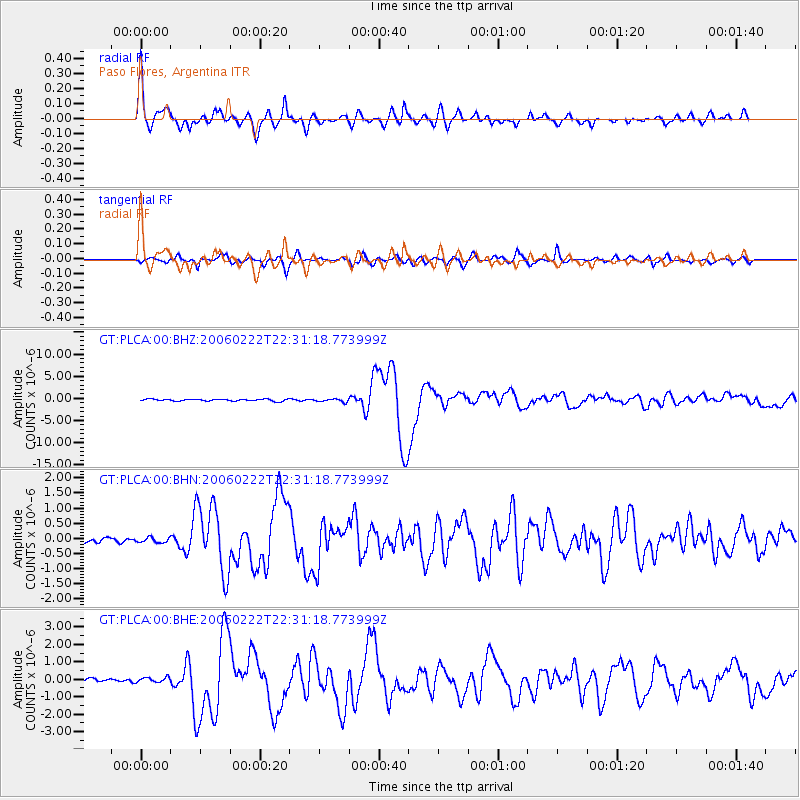
Signal To Noise
| Channel | StoN | STA | LTA |
| GT:PLCA:00:BHN:20060222T22:31:18.773999Z | 0.6550085 | 8.133732E-8 | 1.241775E-7 |
| GT:PLCA:00:BHE:20060222T22:31:18.773999Z | 1.1355035 | 1.5113672E-7 | 1.3310105E-7 |
| GT:PLCA:00:BHZ:20060222T22:31:18.773999Z | 1.77065 | 3.631546E-7 | 2.0509678E-7 |
| Arrivals |
| Ps | 4.3 SECOND |
| PpPs | 15 SECOND |
| PsPs/PpSs | 20 SECOND |


