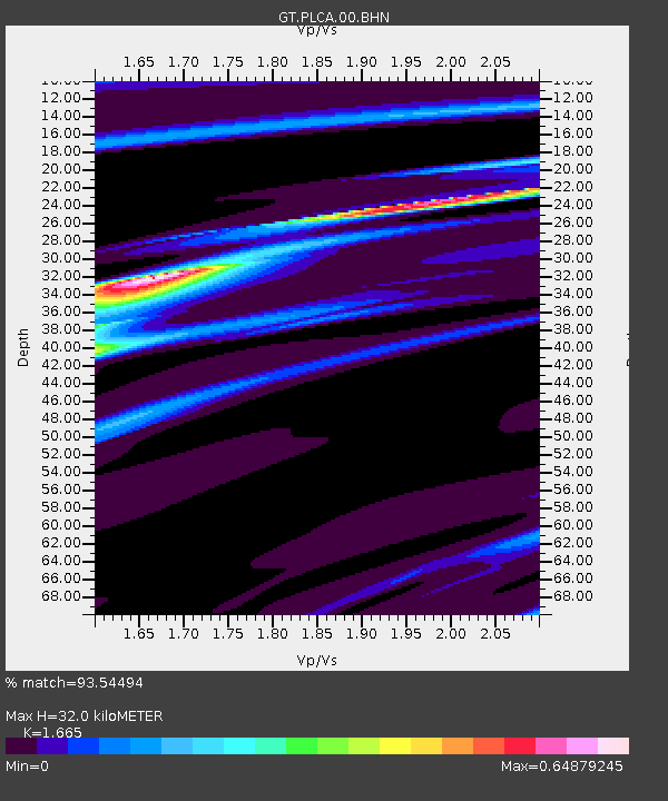
PLCA Paso Flores, Argentina - Earthquake Result Viewer

Earthquake location: Southwestern Atlantic Ocean
Earthquake latitude/longitude: -60.9/-21.6
Earthquake time(UTC): 2006/01/02 (002) 06:10:49 GMT
Earthquake Depth: 10 km
Earthquake Magnitude: 6.4 MB, 7.3 MS, 7.4 MW, 7.1 MW
Earthquake Catalog/Contributor: WHDF/NEIC
Network: GT Global Telemetered Seismograph Network (USAF/USGS)
Station: PLCA Paso Flores, Argentina
Lat/Lon: 40.73 S/70.55 W
Elevation: 1050 m
Distance: 35.8 deg
Az: 281.618 deg
Baz: 140.993 deg
Ray Param: 0.077014886
Estimated Moho Depth: 32.0 km
Estimated Crust Vp/Vs: 1.66
Assumed Crust Vp: 6.597 km/s
Estimated Crust Vs: 3.962 km/s
Estimated Crust Poisson's Ratio: 0.22
Radial Match: 93.54494 %
Radial Bump: 99
Transverse Match: 58.876354 %
Transverse Bump: 400
SOD ConfigId: 4977
Insert Time: 2010-02-27 02:14:48.536 +0000
GWidth: 2.5
Max Bumps: 400
Tol: 0.001

Signal To Noise

ChannelStoNSTALTA
GT:PLCA:00:BHN:20060102T06:17:17.999012Z10.9319561.339622E-61.2254185E-7
GT:PLCA:00:BHE:20060102T06:17:17.999012Z4.33303741.0552678E-62.4354E-7
GT:PLCA:00:BHZ:20060102T06:17:17.999012Z8.4800082.5972186E-63.062755E-7
Arrivals
Ps3.5 SECOND
PpPs12 SECOND
PsPs/PpSs15 SECOND