You are here: Home > Network List > GT - Global Telemetered Seismograph Network (USAF/USGS) Stations List
> Station PLCA Paso Flores, Argentina > Earthquake Result Viewer
PLCA Paso Flores, Argentina - Earthquake Result Viewer
| Earthquake location: |
South Sandwich Islands Region |
| Earthquake latitude/longitude: |
-55.6/-29.9 |
| Earthquake time(UTC): |
2000/11/07 (312) 00:18:04 GMT |
| Earthquake Depth: |
10 km |
| Earthquake Magnitude: |
6.7 MS, 6.8 MW, 6.6 MW |
| Earthquake Catalog/Contributor: |
WHDF/NEIC |
|
| Network: |
GT Global Telemetered Seismograph Network (USAF/USGS) |
| Station: |
PLCA Paso Flores, Argentina |
| Lat/Lon: |
40.73 S/70.55 W |
| Elevation: |
1050 m |
|
| Distance: |
30.4 deg |
| Az: |
282.082 deg |
| Baz: |
133.13 deg |
| Ray Param: |
0.07933373 |
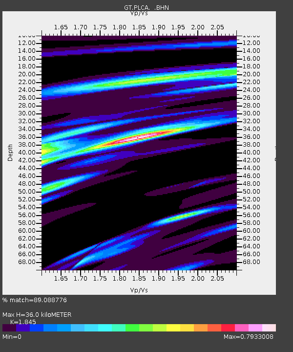
| Estimated Moho Depth: |
36.0 km |
| Estimated Crust Vp/Vs: |
1.85 |
| Assumed Crust Vp: |
6.597 km/s |
| Estimated Crust Vs: |
3.576 km/s |
| Estimated Crust Poisson's Ratio: |
0.29 |
|
| Radial Match: |
89.088776 % |
| Radial Bump: |
336 |
| Transverse Match: |
69.0198 % |
| Transverse Bump: |
400 |
| SOD ConfigId: |
3744 |
| Insert Time: |
2010-02-27 02:14:51.197 +0000 |
| GWidth: |
2.5 |
| Max Bumps: |
400 |
| Tol: |
0.001 |
|

Signal To Noise
| Channel | StoN | STA | LTA |
| GT:PLCA: :BHN:20001107T00:23:46.782986Z | 2.6001122 | 5.5062105E-7 | 2.117682E-7 |
| GT:PLCA: :BHE:20001107T00:23:46.782986Z | 2.0788035 | 6.463643E-7 | 3.1093091E-7 |
| GT:PLCA: :BHZ:20001107T00:23:46.782986Z | 3.5123215 | 1.1330557E-6 | 3.2259453E-7 |
| Arrivals |
| Ps | 5.0 SECOND |
| PpPs | 14 SECOND |
| PsPs/PpSs | 19 SECOND |


