You are here: Home > Network List > US - United States National Seismic Network Stations List
> Station CBKS Cedar Bluff, Kansas, USA > Earthquake Result Viewer
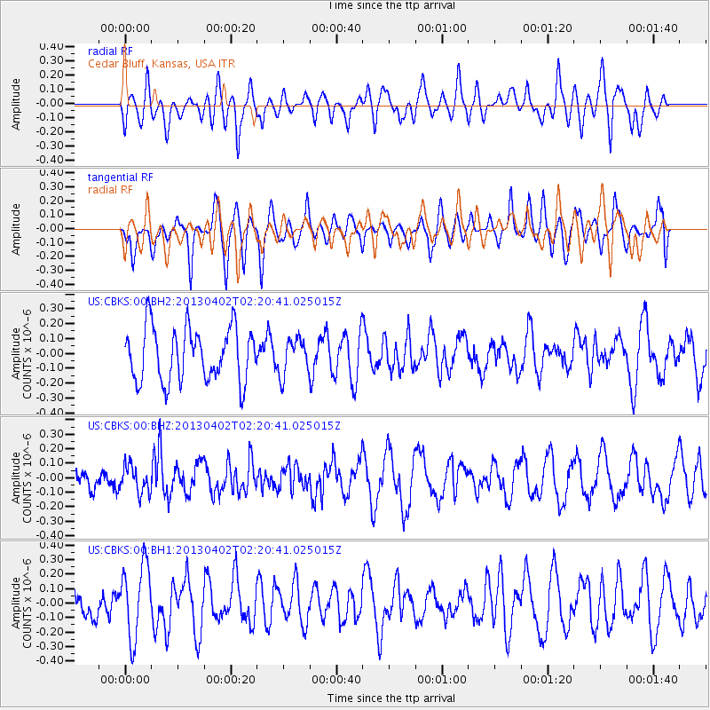
CBKS Cedar Bluff, Kansas, USA - Earthquake Result Viewer
*The percent match for this event was below the threshold and hence no stack was calculated.
| Earthquake location: |
Off East Coast Of Honshu, Japan |
| Earthquake latitude/longitude: |
39.5/143.2 |
| Earthquake time(UTC): |
2013/04/02 (092) 02:08:47 GMT |
| Earthquake Depth: |
17 km |
| Earthquake Magnitude: |
5.5 MW, 5.5 MW |
| Earthquake Catalog/Contributor: |
NEIC PDE/NEIC PDE-W |
|
| Network: |
US United States National Seismic Network |
| Station: |
CBKS Cedar Bluff, Kansas, USA |
| Lat/Lon: |
38.81 N/99.74 W |
| Elevation: |
677 m |
|
| Distance: |
83.1 deg |
| Az: |
44.466 deg |
| Baz: |
316.077 deg |
| Ray Param: |
$rayparam |
*The percent match for this event was below the threshold and hence was not used in the summary stack. |
|
| Radial Match: |
57.875824 % |
| Radial Bump: |
400 |
| Transverse Match: |
65.44528 % |
| Transverse Bump: |
400 |
| SOD ConfigId: |
511491 |
| Insert Time: |
2013-09-05 01:56:03.114 +0000 |
| GWidth: |
2.5 |
| Max Bumps: |
400 |
| Tol: |
0.001 |
|
Signal To Noise
| Channel | StoN | STA | LTA |
| US:CBKS:00:BHZ:20130402T02:20:41.025015Z | 0.9244739 | 9.3527305E-8 | 1.0116814E-7 |
| US:CBKS:00:BH1:20130402T02:20:41.025015Z | 2.09058 | 2.52403E-7 | 1.2073349E-7 |
| US:CBKS:00:BH2:20130402T02:20:41.025015Z | 0.67551225 | 1.2118781E-7 | 1.7940135E-7 |
| Arrivals |
| Ps | |
| PpPs | |
| PsPs/PpSs | |


