You are here: Home > Network List > GT - Global Telemetered Seismograph Network (USAF/USGS) Stations List
> Station PLCA Paso Flores, Argentina > Earthquake Result Viewer
PLCA Paso Flores, Argentina - Earthquake Result Viewer
| Earthquake location: |
West Of Macquarie Island |
| Earthquake latitude/longitude: |
-60.2/149.9 |
| Earthquake time(UTC): |
2000/03/04 (064) 02:24:22 GMT |
| Earthquake Depth: |
10 km |
| Earthquake Magnitude: |
5.5 MB, 6.2 MS, 6.4 MW, 6.3 MW |
| Earthquake Catalog/Contributor: |
WHDF/NEIC |
|
| Network: |
GT Global Telemetered Seismograph Network (USAF/USGS) |
| Station: |
PLCA Paso Flores, Argentina |
| Lat/Lon: |
40.73 S/70.55 W |
| Elevation: |
1050 m |
|
| Distance: |
74.1 deg |
| Az: |
149.185 deg |
| Baz: |
199.697 deg |
| Ray Param: |
0.052548856 |
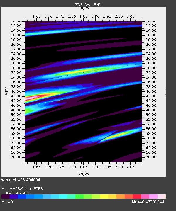
| Estimated Moho Depth: |
43.0 km |
| Estimated Crust Vp/Vs: |
1.60 |
| Assumed Crust Vp: |
6.597 km/s |
| Estimated Crust Vs: |
4.117 km/s |
| Estimated Crust Poisson's Ratio: |
0.18 |
|
| Radial Match: |
85.404884 % |
| Radial Bump: |
307 |
| Transverse Match: |
57.899082 % |
| Transverse Bump: |
329 |
| SOD ConfigId: |
3744 |
| Insert Time: |
2010-02-27 02:14:52.581 +0000 |
| GWidth: |
2.5 |
| Max Bumps: |
400 |
| Tol: |
0.001 |
|
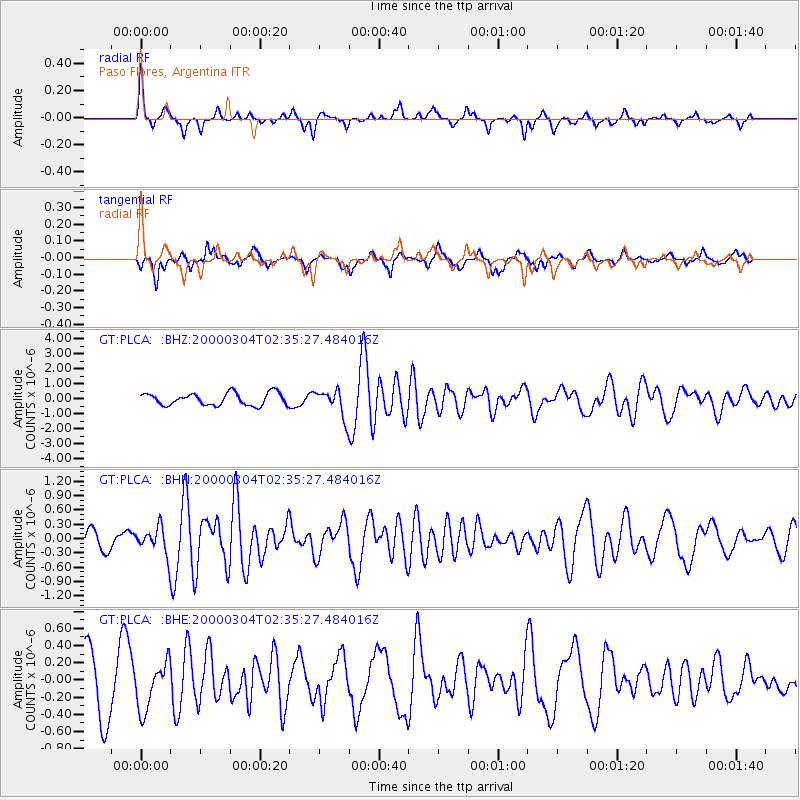
Signal To Noise
| Channel | StoN | STA | LTA |
| GT:PLCA: :BHN:20000304T02:35:27.484016Z | 1.3037047 | 2.789127E-7 | 2.1393856E-7 |
| GT:PLCA: :BHE:20000304T02:35:27.484016Z | 0.7253627 | 2.736855E-7 | 3.7730848E-7 |
| GT:PLCA: :BHZ:20000304T02:35:27.484016Z | 2.202501 | 9.0201894E-7 | 4.0954305E-7 |
| Arrivals |
| Ps | 4.1 SECOND |
| PpPs | 16 SECOND |
| PsPs/PpSs | 20 SECOND |


