PLCA Paso Flores, Argentina - Earthquake Result Viewer
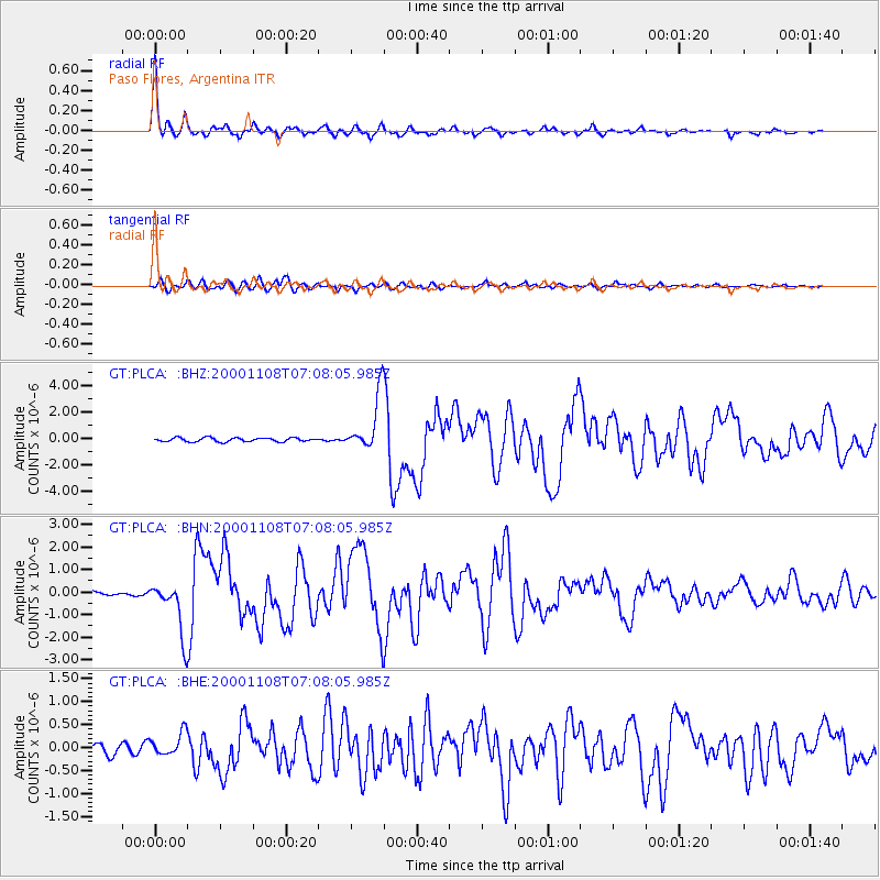
Earthquake location: Panama-Colombia Border Region
Earthquake latitude/longitude: 7.0/-77.8
Earthquake time(UTC): 2000/11/08 (313) 06:59:58 GMT
Earthquake Depth: 17 km
Earthquake Magnitude: 6.0 MB, 6.4 MS, 6.5 MW, 6.2 ML
Earthquake Catalog/Contributor: WHDF/NEIC
Network: GT Global Telemetered Seismograph Network (USAF/USGS)
Station: PLCA Paso Flores, Argentina
Lat/Lon: 40.73 S/70.55 W
Elevation: 1050 m
Distance: 48.0 deg
Az: 172.558 deg
Baz: 350.26 deg
Ray Param: 0.0696137
Estimated Moho Depth: 10.25 km
Estimated Crust Vp/Vs: 2.09
Assumed Crust Vp: 6.597 km/s
Estimated Crust Vs: 3.153 km/s
Estimated Crust Poisson's Ratio: 0.35
Radial Match: 95.581375 %
Radial Bump: 341
Transverse Match: 81.01234 %
Transverse Bump: 400
SOD ConfigId: 3744
Insert Time: 2010-02-27 02:14:53.649 +0000
GWidth: 2.5
Max Bumps: 400
Tol: 0.001

Signal To Noise

ChannelStoNSTALTA
GT:PLCA: :BHN:20001108T07:08:05.985Z8.2665231.1592043E-61.4022875E-7
GT:PLCA: :BHE:20001108T07:08:05.985Z1.17917242.477516E-72.1010634E-7
GT:PLCA: :BHZ:20001108T07:08:05.985Z13.935072.0556913E-61.4751926E-7
Arrivals
Ps1.8 SECOND
PpPs4.6 SECOND
PsPs/PpSs6.3 SECOND