You are here: Home > Network List > TA - USArray Transportable Network (new EarthScope stations) Stations List
> Station G59A Clarenceville, QC, USA > Earthquake Result Viewer
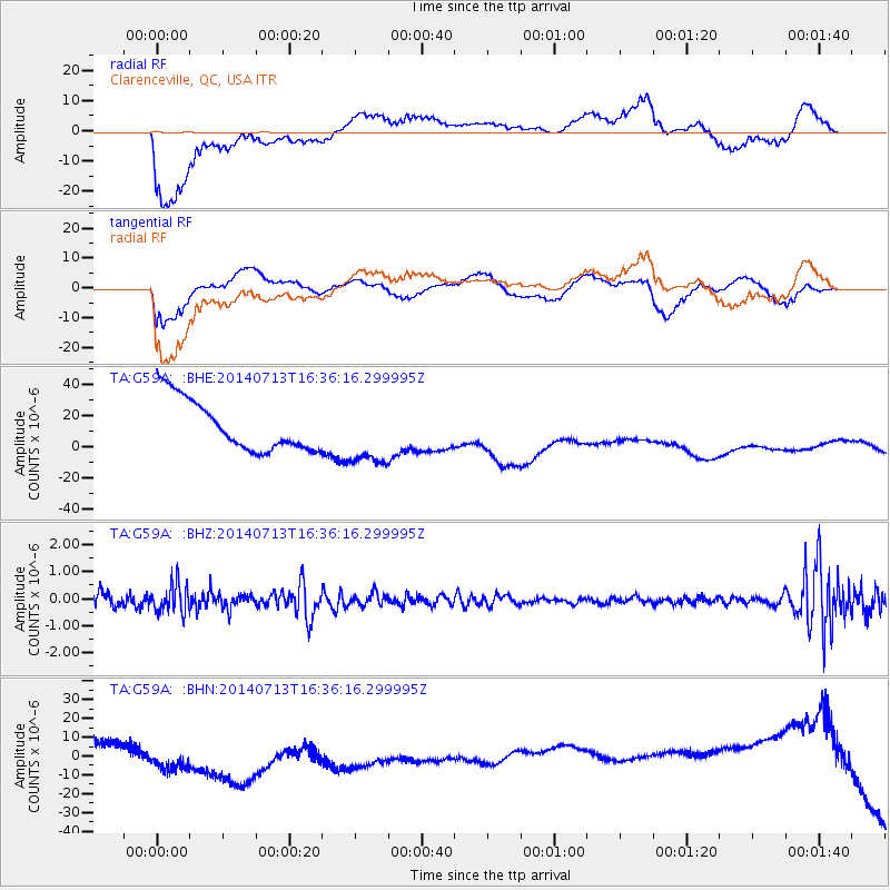
G59A Clarenceville, QC, USA - Earthquake Result Viewer
*The percent match for this event was below the threshold and hence no stack was calculated.
| Earthquake location: |
Hindu Kush Region, Afghanistan |
| Earthquake latitude/longitude: |
36.4/67.7 |
| Earthquake time(UTC): |
2014/07/13 (194) 16:23:44 GMT |
| Earthquake Depth: |
35 km |
| Earthquake Magnitude: |
5.0 MW, 5.0 mb |
| Earthquake Catalog/Contributor: |
ISC/ISC |
|
| Network: |
TA USArray Transportable Network (new EarthScope stations) |
| Station: |
G59A Clarenceville, QC, USA |
| Lat/Lon: |
45.08 N/73.18 W |
| Elevation: |
36 m |
|
| Distance: |
91.5 deg |
| Az: |
333.44 deg |
| Baz: |
30.606 deg |
| Ray Param: |
$rayparam |
*The percent match for this event was below the threshold and hence was not used in the summary stack. |
|
| Radial Match: |
39.65199 % |
| Radial Bump: |
400 |
| Transverse Match: |
43.769543 % |
| Transverse Bump: |
400 |
| SOD ConfigId: |
3390531 |
| Insert Time: |
2019-04-12 20:18:59.436 +0000 |
| GWidth: |
2.5 |
| Max Bumps: |
400 |
| Tol: |
0.001 |
|
Signal To Noise
| Channel | StoN | STA | LTA |
| TA:G59A: :BHZ:20140713T16:36:16.299995Z | 2.4347425 | 5.433821E-7 | 2.2317846E-7 |
| TA:G59A: :BHN:20140713T16:36:16.299995Z | 3.0974734 | 1.6218837E-5 | 5.2361506E-6 |
| TA:G59A: :BHE:20140713T16:36:16.299995Z | 1.2594935 | 2.0821783E-5 | 1.653187E-5 |
| Arrivals |
| Ps | |
| PpPs | |
| PsPs/PpSs | |


