You are here: Home > Network List > GT - Global Telemetered Seismograph Network (USAF/USGS) Stations List
> Station PLCA Paso Flores, Argentina > Earthquake Result Viewer
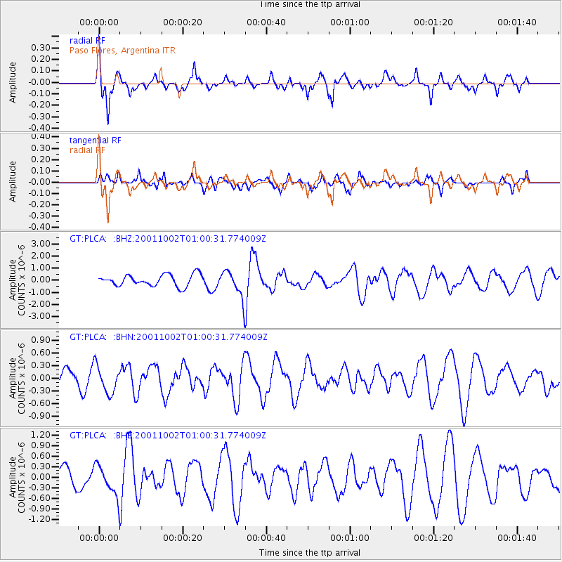
PLCA Paso Flores, Argentina - Earthquake Result Viewer

| Earthquake location: |
Tonga Islands |
| Earthquake latitude/longitude: |
-16.2/-173.8 |
| Earthquake time(UTC): |
2001/10/02 (275) 00:48:18 GMT |
| Earthquake Depth: |
107 km |
| Earthquake Magnitude: |
5.8 MB, 6.2 MW, 6.1 MW |
| Earthquake Catalog/Contributor: |
WHDF/NEIC |
|
| Network: |
GT Global Telemetered Seismograph Network (USAF/USGS) |
| Station: |
PLCA Paso Flores, Argentina |
| Lat/Lon: |
40.73 S/70.55 W |
| Elevation: |
1050 m |
|
| Distance: |
89.3 deg |
| Az: |
132.295 deg |
| Baz: |
249.276 deg |
| Ray Param: |
0.041743685 |
| Estimated Moho Depth: |
34.25 km |
| Estimated Crust Vp/Vs: |
1.88 |
| Assumed Crust Vp: |
6.597 km/s |
| Estimated Crust Vs: |
3.519 km/s |
| Estimated Crust Poisson's Ratio: |
0.30 |
|
| Radial Match: |
81.21691 % |
| Radial Bump: |
400 |
| Transverse Match: |
61.757797 % |
| Transverse Bump: |
400 |
| SOD ConfigId: |
20082 |
| Insert Time: |
2010-02-27 02:15:02.968 +0000 |
| GWidth: |
2.5 |
| Max Bumps: |
400 |
| Tol: |
0.001 |
|
Signal To Noise
| Channel | StoN | STA | LTA |
| GT:PLCA: :BHN:20011002T01:00:31.774009Z | 0.786353 | 3.0663918E-7 | 3.8995105E-7 |
| GT:PLCA: :BHE:20011002T01:00:31.774009Z | 2.0425615 | 4.509817E-7 | 2.2079222E-7 |
| GT:PLCA: :BHZ:20011002T01:00:31.774009Z | 2.4520655 | 1.1586465E-6 | 4.7251856E-7 |
| Arrivals |
| Ps | 4.6 SECOND |
| PpPs | 15 SECOND |
| PsPs/PpSs | 19 SECOND |


