You are here: Home > Network List > GT - Global Telemetered Seismograph Network (USAF/USGS) Stations List
> Station PLCA Paso Flores, Argentina > Earthquake Result Viewer
PLCA Paso Flores, Argentina - Earthquake Result Viewer
| Earthquake location: |
El Salvador |
| Earthquake latitude/longitude: |
13.0/-88.7 |
| Earthquake time(UTC): |
2001/01/13 (013) 17:33:32 GMT |
| Earthquake Depth: |
60 km |
| Earthquake Magnitude: |
6.4 MB, 7.8 MS, 7.7 MW, 7.5 ME |
| Earthquake Catalog/Contributor: |
WHDF/NEIC |
|
| Network: |
GT Global Telemetered Seismograph Network (USAF/USGS) |
| Station: |
PLCA Paso Flores, Argentina |
| Lat/Lon: |
40.73 S/70.55 W |
| Elevation: |
1050 m |
|
| Distance: |
56.1 deg |
| Az: |
163.462 deg |
| Baz: |
338.591 deg |
| Ray Param: |
0.064221084 |
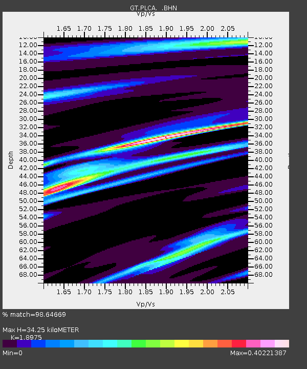
| Estimated Moho Depth: |
34.25 km |
| Estimated Crust Vp/Vs: |
1.90 |
| Assumed Crust Vp: |
6.597 km/s |
| Estimated Crust Vs: |
3.477 km/s |
| Estimated Crust Poisson's Ratio: |
0.31 |
|
| Radial Match: |
98.64669 % |
| Radial Bump: |
201 |
| Transverse Match: |
95.66583 % |
| Transverse Bump: |
400 |
| SOD ConfigId: |
3744 |
| Insert Time: |
2010-02-27 02:15:06.065 +0000 |
| GWidth: |
2.5 |
| Max Bumps: |
400 |
| Tol: |
0.001 |
|
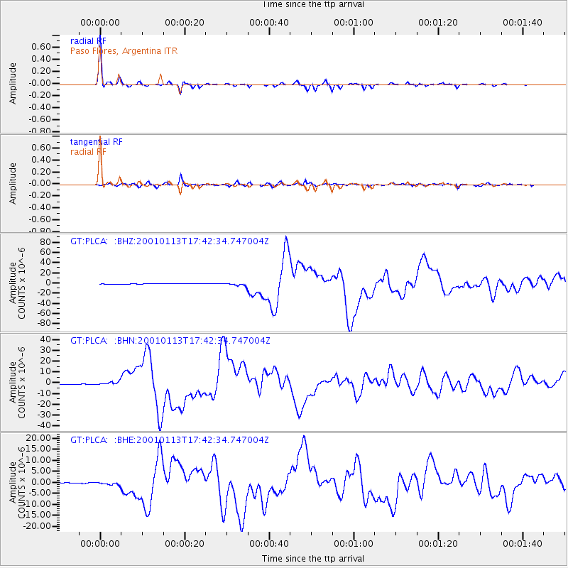
Signal To Noise
| Channel | StoN | STA | LTA |
| GT:PLCA: :BHN:20010113T17:42:34.747004Z | 5.56383 | 1.586864E-6 | 2.8521072E-7 |
| GT:PLCA: :BHE:20010113T17:42:34.747004Z | 3.1273394 | 6.790687E-7 | 2.1713944E-7 |
| GT:PLCA: :BHZ:20010113T17:42:34.747004Z | 8.351516 | 2.9911564E-6 | 3.5815728E-7 |
| Arrivals |
| Ps | 4.9 SECOND |
| PpPs | 14 SECOND |
| PsPs/PpSs | 19 SECOND |


