You are here: Home > Network List > GT - Global Telemetered Seismograph Network (USAF/USGS) Stations List
> Station PLCA Paso Flores, Argentina > Earthquake Result Viewer
PLCA Paso Flores, Argentina - Earthquake Result Viewer
| Earthquake location: |
Southeast Of Loyalty Islands |
| Earthquake latitude/longitude: |
-22.0/170.1 |
| Earthquake time(UTC): |
2001/02/28 (059) 13:05:31 GMT |
| Earthquake Depth: |
10 km |
| Earthquake Magnitude: |
5.8 MB, 6.1 MS, 6.2 MW |
| Earthquake Catalog/Contributor: |
WHDF/NEIC |
|
| Network: |
GT Global Telemetered Seismograph Network (USAF/USGS) |
| Station: |
PLCA Paso Flores, Argentina |
| Lat/Lon: |
40.73 S/70.55 W |
| Elevation: |
1050 m |
|
| Distance: |
95.9 deg |
| Az: |
138.24 deg |
| Baz: |
234.425 deg |
| Ray Param: |
0.040649485 |
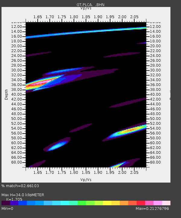
| Estimated Moho Depth: |
34.0 km |
| Estimated Crust Vp/Vs: |
1.71 |
| Assumed Crust Vp: |
6.597 km/s |
| Estimated Crust Vs: |
3.87 km/s |
| Estimated Crust Poisson's Ratio: |
0.24 |
|
| Radial Match: |
82.66103 % |
| Radial Bump: |
400 |
| Transverse Match: |
49.974876 % |
| Transverse Bump: |
384 |
| SOD ConfigId: |
3744 |
| Insert Time: |
2010-02-27 02:15:07.799 +0000 |
| GWidth: |
2.5 |
| Max Bumps: |
400 |
| Tol: |
0.001 |
|

Signal To Noise
| Channel | StoN | STA | LTA |
| GT:PLCA: :BHN:20010228T13:18:26.897019Z | 0.7591448 | 5.5276473E-7 | 7.2814134E-7 |
| GT:PLCA: :BHE:20010228T13:18:26.897019Z | 0.4810487 | 1.8761887E-7 | 3.9002052E-7 |
| GT:PLCA: :BHZ:20010228T13:18:26.897019Z | 1.2686982 | 7.8603324E-7 | 6.1955893E-7 |
| Arrivals |
| Ps | 3.7 SECOND |
| PpPs | 14 SECOND |
| PsPs/PpSs | 17 SECOND |


