You are here: Home > Network List > GT - Global Telemetered Seismograph Network (USAF/USGS) Stations List
> Station PLCA Paso Flores, Argentina > Earthquake Result Viewer
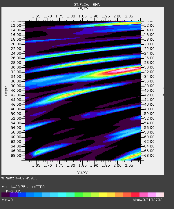
PLCA Paso Flores, Argentina - Earthquake Result Viewer
| Earthquake location: |
Near Coast Of Chiapas, Mexico |
| Earthquake latitude/longitude: |
15.5/-93.1 |
| Earthquake time(UTC): |
2002/01/16 (016) 23:09:52 GMT |
| Earthquake Depth: |
80 km |
| Earthquake Magnitude: |
5.8 MB, 6.4 MW, 6.4 MW |
| Earthquake Catalog/Contributor: |
WHDF/NEIC |
|
| Network: |
GT Global Telemetered Seismograph Network (USAF/USGS) |
| Station: |
PLCA Paso Flores, Argentina |
| Lat/Lon: |
40.73 S/70.55 W |
| Elevation: |
1050 m |
|
| Distance: |
59.7 deg |
| Az: |
160.256 deg |
| Baz: |
334.622 deg |
| Ray Param: |
0.061768077 |
| Estimated Moho Depth: |
30.75 km |
| Estimated Crust Vp/Vs: |
2.04 |
| Assumed Crust Vp: |
6.597 km/s |
| Estimated Crust Vs: |
3.242 km/s |
| Estimated Crust Poisson's Ratio: |
0.34 |
|
| Radial Match: |
89.45913 % |
| Radial Bump: |
306 |
| Transverse Match: |
68.09916 % |
| Transverse Bump: |
400 |
| SOD ConfigId: |
4714 |
| Insert Time: |
2010-02-27 02:15:08.948 +0000 |
| GWidth: |
2.5 |
| Max Bumps: |
400 |
| Tol: |
0.001 |
|

Signal To Noise
| Channel | StoN | STA | LTA |
| GT:PLCA: :BHN:20020116T23:19:17.884016Z | 4.838982 | 8.401913E-7 | 1.7362977E-7 |
| GT:PLCA: :BHE:20020116T23:19:17.884016Z | 1.5150453 | 3.5661859E-7 | 2.3538477E-7 |
| GT:PLCA: :BHZ:20020116T23:19:17.884016Z | 6.3175693 | 1.4931691E-6 | 2.3635182E-7 |
| Arrivals |
| Ps | 5.0 SECOND |
| PpPs | 14 SECOND |
| PsPs/PpSs | 19 SECOND |


