You are here: Home > Network List > IU - Global Seismograph Network (GSN - IRIS/USGS) Stations List
> Station GNI Garni, Armenia > Earthquake Result Viewer
GNI Garni, Armenia - Earthquake Result Viewer
| Earthquake location: |
Southwest Indian Ridge |
| Earthquake latitude/longitude: |
-40.4/45.4 |
| Earthquake time(UTC): |
2013/04/02 (092) 14:34:55 GMT |
| Earthquake Depth: |
9.0 km |
| Earthquake Magnitude: |
5.9 MW, 5.8 MS, 5.8 MW, 5.9 MB |
| Earthquake Catalog/Contributor: |
NEIC PDE/NEIC PDE-W |
|
| Network: |
IU Global Seismograph Network (GSN - IRIS/USGS) |
| Station: |
GNI Garni, Armenia |
| Lat/Lon: |
40.15 N/44.74 E |
| Elevation: |
1609 m |
|
| Distance: |
80.2 deg |
| Az: |
359.501 deg |
| Baz: |
179.504 deg |
| Ray Param: |
0.048430234 |
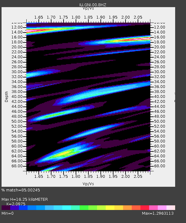
| Estimated Moho Depth: |
16.25 km |
| Estimated Crust Vp/Vs: |
2.10 |
| Assumed Crust Vp: |
6.291 km/s |
| Estimated Crust Vs: |
2.999 km/s |
| Estimated Crust Poisson's Ratio: |
0.35 |
|
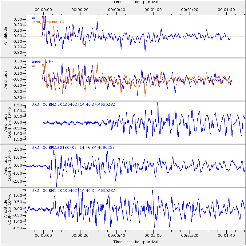
| Radial Match: |
85.00245 % |
| Radial Bump: |
400 |
| Transverse Match: |
79.54466 % |
| Transverse Bump: |
400 |
| SOD ConfigId: |
511491 |
| Insert Time: |
2013-09-05 02:02:49.900 +0000 |
| GWidth: |
2.5 |
| Max Bumps: |
400 |
| Tol: |
0.001 |
|
Signal To Noise
| Channel | StoN | STA | LTA |
| IU:GNI:00:BHZ:20130402T14:46:34.469028Z | 9.008643 | 6.48989E-7 | 7.20407E-8 |
| IU:GNI:00:BH1:20130402T14:46:34.469028Z | 0.94863594 | 1.1185903E-7 | 1.17915654E-7 |
| IU:GNI:00:BH2:20130402T14:46:34.469028Z | 1.7347767 | 1.2083704E-7 | 6.965568E-8 |
| Arrivals |
| Ps | 2.9 SECOND |
| PpPs | 7.8 SECOND |
| PsPs/PpSs | 11 SECOND |


