You are here: Home > Network List > IU - Global Seismograph Network (GSN - IRIS/USGS) Stations List
> Station KBL Kabul, Afghanistan > Earthquake Result Viewer
KBL Kabul, Afghanistan - Earthquake Result Viewer
| Earthquake location: |
Southwest Indian Ridge |
| Earthquake latitude/longitude: |
-40.4/45.4 |
| Earthquake time(UTC): |
2013/04/02 (092) 14:34:55 GMT |
| Earthquake Depth: |
9.0 km |
| Earthquake Magnitude: |
5.9 MW, 5.8 MS, 5.8 MW, 5.9 MB |
| Earthquake Catalog/Contributor: |
NEIC PDE/NEIC PDE-W |
|
| Network: |
IU Global Seismograph Network (GSN - IRIS/USGS) |
| Station: |
KBL Kabul, Afghanistan |
| Lat/Lon: |
34.54 N/69.04 E |
| Elevation: |
1920 m |
|
| Distance: |
77.7 deg |
| Az: |
19.817 deg |
| Baz: |
198.266 deg |
| Ray Param: |
0.050117683 |
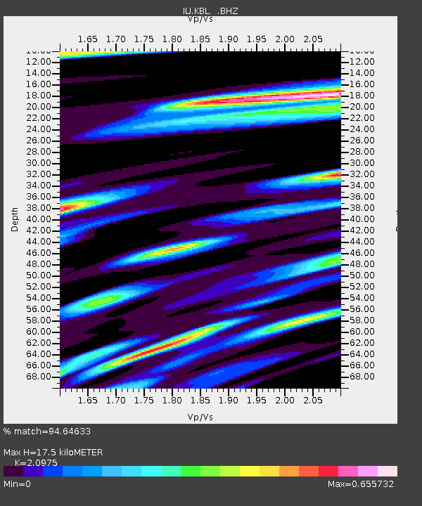
| Estimated Moho Depth: |
17.5 km |
| Estimated Crust Vp/Vs: |
2.10 |
| Assumed Crust Vp: |
6.641 km/s |
| Estimated Crust Vs: |
3.166 km/s |
| Estimated Crust Poisson's Ratio: |
0.35 |
|
| Radial Match: |
94.64633 % |
| Radial Bump: |
400 |
| Transverse Match: |
87.197334 % |
| Transverse Bump: |
400 |
| SOD ConfigId: |
511491 |
| Insert Time: |
2013-09-05 02:02:51.612 +0000 |
| GWidth: |
2.5 |
| Max Bumps: |
400 |
| Tol: |
0.001 |
|
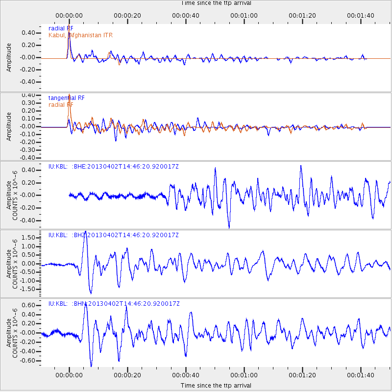
Signal To Noise
| Channel | StoN | STA | LTA |
| IU:KBL: :BHZ:20130402T14:46:20.920017Z | 4.467623 | 3.0325833E-7 | 6.7879114E-8 |
| IU:KBL: :BHN:20130402T14:46:20.920017Z | 2.9647157 | 7.712807E-8 | 2.6015334E-8 |
| IU:KBL: :BHE:20130402T14:46:20.920017Z | 2.236479 | 6.2283945E-8 | 2.7849106E-8 |
| Arrivals |
| Ps | 3.0 SECOND |
| PpPs | 7.9 SECOND |
| PsPs/PpSs | 11 SECOND |


