You are here: Home > Network List > GT - Global Telemetered Seismograph Network (USAF/USGS) Stations List
> Station PLCA Paso Flores, Argentina > Earthquake Result Viewer
PLCA Paso Flores, Argentina - Earthquake Result Viewer

| Earthquake location: |
South Sandwich Islands Region |
| Earthquake latitude/longitude: |
-56.5/-27.5 |
| Earthquake time(UTC): |
2002/11/12 (316) 01:46:48 GMT |
| Earthquake Depth: |
120 km |
| Earthquake Magnitude: |
6.0 MB, 6.3 MW, 6.2 MW |
| Earthquake Catalog/Contributor: |
WHDF/NEIC |
|
| Network: |
GT Global Telemetered Seismograph Network (USAF/USGS) |
| Station: |
PLCA Paso Flores, Argentina |
| Lat/Lon: |
40.73 S/70.55 W |
| Elevation: |
1050 m |
|
| Distance: |
31.9 deg |
| Az: |
281.204 deg |
| Baz: |
134.369 deg |
| Ray Param: |
0.078551225 |
| Estimated Moho Depth: |
63.5 km |
| Estimated Crust Vp/Vs: |
2.03 |
| Assumed Crust Vp: |
6.597 km/s |
| Estimated Crust Vs: |
3.246 km/s |
| Estimated Crust Poisson's Ratio: |
0.34 |
|
| Radial Match: |
81.1242 % |
| Radial Bump: |
331 |
| Transverse Match: |
42.621845 % |
| Transverse Bump: |
393 |
| SOD ConfigId: |
4714 |
| Insert Time: |
2010-02-27 02:15:10.471 +0000 |
| GWidth: |
2.5 |
| Max Bumps: |
400 |
| Tol: |
0.001 |
|
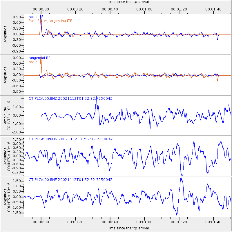
Signal To Noise
| Channel | StoN | STA | LTA |
| GT:PLCA:00:BHN:20021112T01:52:32.725004Z | 2.1086335 | 3.129358E-7 | 1.4840691E-7 |
| GT:PLCA:00:BHE:20021112T01:52:32.725004Z | 1.8017083 | 4.200306E-7 | 2.3312907E-7 |
| GT:PLCA:00:BHZ:20021112T01:52:32.725004Z | 3.9114025 | 9.576308E-7 | 2.4483057E-7 |
| Arrivals |
| Ps | 11 SECOND |
| PpPs | 27 SECOND |
| PsPs/PpSs | 38 SECOND |


