You are here: Home > Network List > IU - Global Seismograph Network (GSN - IRIS/USGS) Stations List
> Station KMBO Kilima Mbogo, Kenya > Earthquake Result Viewer
KMBO Kilima Mbogo, Kenya - Earthquake Result Viewer

| Earthquake location: |
Southwest Indian Ridge |
| Earthquake latitude/longitude: |
-40.4/45.4 |
| Earthquake time(UTC): |
2013/04/02 (092) 14:34:55 GMT |
| Earthquake Depth: |
9.0 km |
| Earthquake Magnitude: |
5.9 MW, 5.8 MS, 5.8 MW, 5.9 MB |
| Earthquake Catalog/Contributor: |
NEIC PDE/NEIC PDE-W |
|
| Network: |
IU Global Seismograph Network (GSN - IRIS/USGS) |
| Station: |
KMBO Kilima Mbogo, Kenya |
| Lat/Lon: |
1.13 S/37.25 E |
| Elevation: |
1950 m |
|
| Distance: |
39.8 deg |
| Az: |
347.247 deg |
| Baz: |
170.299 deg |
| Ray Param: |
0.07475976 |
| Estimated Moho Depth: |
36.75 km |
| Estimated Crust Vp/Vs: |
1.81 |
| Assumed Crust Vp: |
6.601 km/s |
| Estimated Crust Vs: |
3.647 km/s |
| Estimated Crust Poisson's Ratio: |
0.28 |
|
| Radial Match: |
95.24174 % |
| Radial Bump: |
194 |
| Transverse Match: |
59.44251 % |
| Transverse Bump: |
400 |
| SOD ConfigId: |
511491 |
| Insert Time: |
2013-09-05 02:02:56.221 +0000 |
| GWidth: |
2.5 |
| Max Bumps: |
400 |
| Tol: |
0.001 |
|
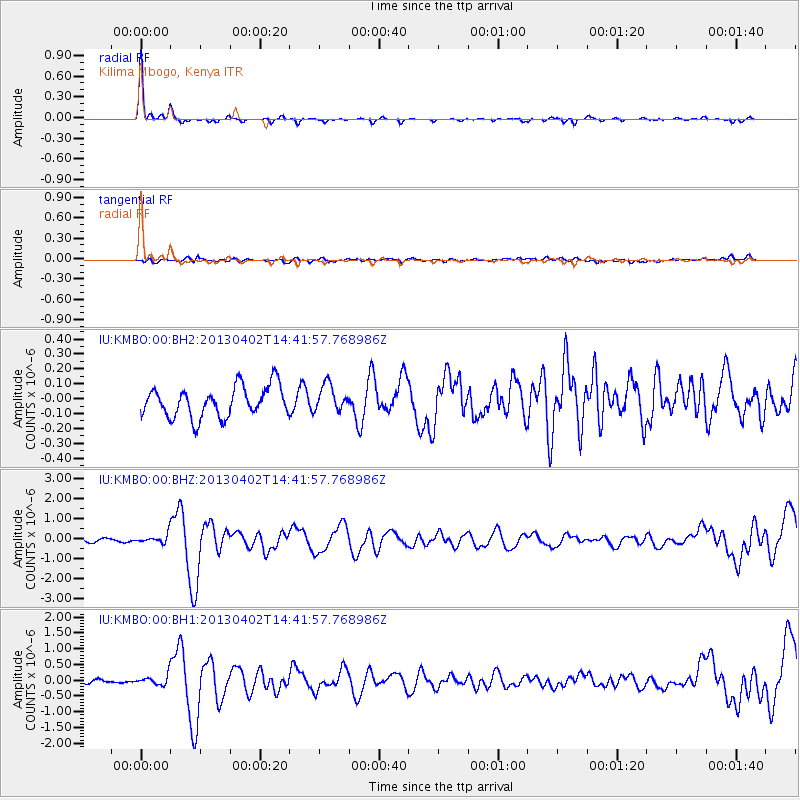
Signal To Noise
| Channel | StoN | STA | LTA |
| IU:KMBO:00:BHZ:20130402T14:41:57.768986Z | 3.2412493 | 2.2680376E-7 | 6.9974185E-8 |
| IU:KMBO:00:BH1:20130402T14:41:57.768986Z | 2.0352676 | 1.6916519E-7 | 8.311693E-8 |
| IU:KMBO:00:BH2:20130402T14:41:57.768986Z | 0.85772884 | 8.829017E-8 | 1.0293483E-7 |
| Arrivals |
| Ps | 4.9 SECOND |
| PpPs | 15 SECOND |
| PsPs/PpSs | 19 SECOND |


