You are here: Home > Network List > GT - Global Telemetered Seismograph Network (USAF/USGS) Stations List
> Station PLCA Paso Flores, Argentina > Earthquake Result Viewer
PLCA Paso Flores, Argentina - Earthquake Result Viewer
| Earthquake location: |
Central Mexico |
| Earthquake latitude/longitude: |
18.4/-97.4 |
| Earthquake time(UTC): |
1999/06/15 (166) 20:42:05 GMT |
| Earthquake Depth: |
70 km |
| Earthquake Magnitude: |
6.4 MB, 6.5 MS, 7.0 MW, 6.7 ME |
| Earthquake Catalog/Contributor: |
WHDF/NEIC |
|
| Network: |
GT Global Telemetered Seismograph Network (USAF/USGS) |
| Station: |
PLCA Paso Flores, Argentina |
| Lat/Lon: |
40.73 S/70.55 W |
| Elevation: |
1050 m |
|
| Distance: |
63.9 deg |
| Az: |
157.503 deg |
| Baz: |
331.436 deg |
| Ray Param: |
0.05909549 |
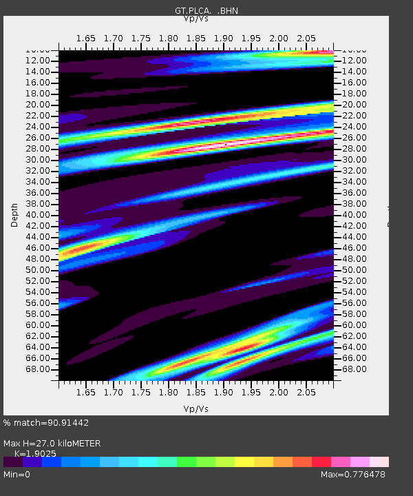
| Estimated Moho Depth: |
27.0 km |
| Estimated Crust Vp/Vs: |
1.90 |
| Assumed Crust Vp: |
6.597 km/s |
| Estimated Crust Vs: |
3.468 km/s |
| Estimated Crust Poisson's Ratio: |
0.31 |
|
| Radial Match: |
90.91442 % |
| Radial Bump: |
400 |
| Transverse Match: |
81.6174 % |
| Transverse Bump: |
400 |
| SOD ConfigId: |
4480 |
| Insert Time: |
2010-02-27 02:15:11.424 +0000 |
| GWidth: |
2.5 |
| Max Bumps: |
400 |
| Tol: |
0.001 |
|

Signal To Noise
| Channel | StoN | STA | LTA |
| GT:PLCA: :BHN:19990615T20:52:00.711006Z | 3.1090515 | 1.098418E-6 | 3.5329683E-7 |
| GT:PLCA: :BHE:19990615T20:52:00.711006Z | 3.2320983 | 4.8944275E-7 | 1.514319E-7 |
| GT:PLCA: :BHZ:19990615T20:52:00.711006Z | 1.8627288 | 4.983144E-7 | 2.6751852E-7 |
| Arrivals |
| Ps | 3.9 SECOND |
| PpPs | 11 SECOND |
| PsPs/PpSs | 15 SECOND |


