You are here: Home > Network List > GT - Global Telemetered Seismograph Network (USAF/USGS) Stations List
> Station PLCA Paso Flores, Argentina > Earthquake Result Viewer
PLCA Paso Flores, Argentina - Earthquake Result Viewer
| Earthquake location: |
Colombia |
| Earthquake latitude/longitude: |
3.9/-75.8 |
| Earthquake time(UTC): |
1997/12/11 (345) 07:56:28 GMT |
| Earthquake Depth: |
178 km |
| Earthquake Magnitude: |
6.0 MB, 6.4 UNKNOWN, 6.3 MW |
| Earthquake Catalog/Contributor: |
WHDF/NEIC |
|
| Network: |
GT Global Telemetered Seismograph Network (USAF/USGS) |
| Station: |
PLCA Paso Flores, Argentina |
| Lat/Lon: |
40.73 S/70.55 W |
| Elevation: |
1050 m |
|
| Distance: |
44.7 deg |
| Az: |
174.342 deg |
| Baz: |
352.563 deg |
| Ray Param: |
0.0710677 |
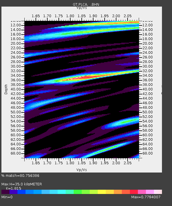
| Estimated Moho Depth: |
35.0 km |
| Estimated Crust Vp/Vs: |
1.82 |
| Assumed Crust Vp: |
6.597 km/s |
| Estimated Crust Vs: |
3.635 km/s |
| Estimated Crust Poisson's Ratio: |
0.28 |
|
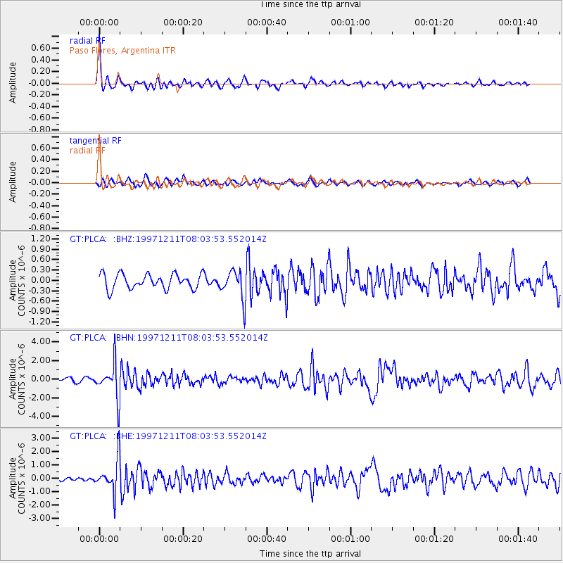
| Radial Match: |
80.756386 % |
| Radial Bump: |
337 |
| Transverse Match: |
69.14191 % |
| Transverse Bump: |
400 |
| SOD ConfigId: |
4480 |
| Insert Time: |
2010-02-27 02:15:13.517 +0000 |
| GWidth: |
2.5 |
| Max Bumps: |
400 |
| Tol: |
0.001 |
|
Signal To Noise
| Channel | StoN | STA | LTA |
| GT:PLCA: :BHN:19971211T08:03:53.552014Z | 8.041024 | 1.926716E-6 | 2.3961078E-7 |
| GT:PLCA: :BHE:19971211T08:03:53.552014Z | 9.545839 | 1.2714946E-6 | 1.3319882E-7 |
| GT:PLCA: :BHZ:19971211T08:03:53.552014Z | 1.9930674 | 4.241389E-7 | 2.1280711E-7 |
| Arrivals |
| Ps | 4.6 SECOND |
| PpPs | 14 SECOND |
| PsPs/PpSs | 19 SECOND |


