You are here: Home > Network List > GT - Global Telemetered Seismograph Network (USAF/USGS) Stations List
> Station PLCA Paso Flores, Argentina > Earthquake Result Viewer
PLCA Paso Flores, Argentina - Earthquake Result Viewer
| Earthquake location: |
South Sandwich Islands Region |
| Earthquake latitude/longitude: |
-58.0/-25.3 |
| Earthquake time(UTC): |
2004/09/11 (255) 21:52:38 GMT |
| Earthquake Depth: |
64 km |
| Earthquake Magnitude: |
5.8 MB, 6.1 MW, 6.1 MW |
| Earthquake Catalog/Contributor: |
WHDF/NEIC |
|
| Network: |
GT Global Telemetered Seismograph Network (USAF/USGS) |
| Station: |
PLCA Paso Flores, Argentina |
| Lat/Lon: |
40.73 S/70.55 W |
| Elevation: |
1050 m |
|
| Distance: |
33.4 deg |
| Az: |
281.192 deg |
| Baz: |
136.541 deg |
| Ray Param: |
0.07809123 |
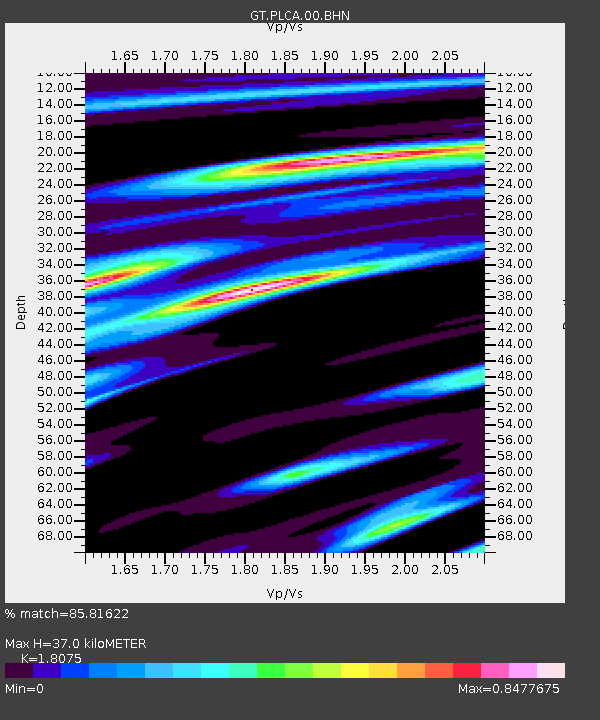
| Estimated Moho Depth: |
37.0 km |
| Estimated Crust Vp/Vs: |
1.81 |
| Assumed Crust Vp: |
6.597 km/s |
| Estimated Crust Vs: |
3.65 km/s |
| Estimated Crust Poisson's Ratio: |
0.28 |
|
| Radial Match: |
85.81622 % |
| Radial Bump: |
321 |
| Transverse Match: |
78.71156 % |
| Transverse Bump: |
400 |
| SOD ConfigId: |
2459 |
| Insert Time: |
2010-02-27 02:15:18.662 +0000 |
| GWidth: |
2.5 |
| Max Bumps: |
400 |
| Tol: |
0.001 |
|

Signal To Noise
| Channel | StoN | STA | LTA |
| GT:PLCA:00:BHN:20040911T21:58:40.025006Z | 4.2811484 | 1.0521221E-6 | 2.4575698E-7 |
| GT:PLCA:00:BHE:20040911T21:58:40.025006Z | 2.8760796 | 8.630414E-7 | 3.000756E-7 |
| GT:PLCA:00:BHZ:20040911T21:58:40.025006Z | 5.979649 | 2.4155897E-6 | 4.0396847E-7 |
| Arrivals |
| Ps | 4.9 SECOND |
| PpPs | 15 SECOND |
| PsPs/PpSs | 19 SECOND |


