You are here: Home > Network List > GT - Global Telemetered Seismograph Network (USAF/USGS) Stations List
> Station PLCA Paso Flores, Argentina > Earthquake Result Viewer
PLCA Paso Flores, Argentina - Earthquake Result Viewer
| Earthquake location: |
Ecuador |
| Earthquake latitude/longitude: |
-1.4/-77.5 |
| Earthquake time(UTC): |
2005/12/23 (357) 21:47:28 GMT |
| Earthquake Depth: |
193 km |
| Earthquake Magnitude: |
5.8 MB, 6.1 MW, 6.1 MW |
| Earthquake Catalog/Contributor: |
WHDF/NEIC |
|
| Network: |
GT Global Telemetered Seismograph Network (USAF/USGS) |
| Station: |
PLCA Paso Flores, Argentina |
| Lat/Lon: |
40.73 S/70.55 W |
| Elevation: |
1050 m |
|
| Distance: |
39.7 deg |
| Az: |
171.699 deg |
| Baz: |
349.051 deg |
| Ray Param: |
0.07412268 |
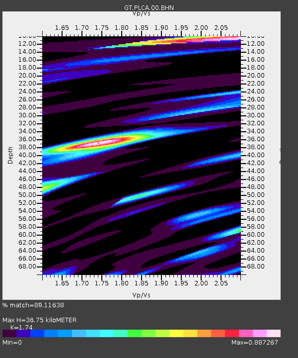
| Estimated Moho Depth: |
36.75 km |
| Estimated Crust Vp/Vs: |
1.74 |
| Assumed Crust Vp: |
6.597 km/s |
| Estimated Crust Vs: |
3.792 km/s |
| Estimated Crust Poisson's Ratio: |
0.25 |
|
| Radial Match: |
89.11638 % |
| Radial Bump: |
337 |
| Transverse Match: |
72.86576 % |
| Transverse Bump: |
400 |
| SOD ConfigId: |
2422 |
| Insert Time: |
2010-02-27 02:15:30.647 +0000 |
| GWidth: |
2.5 |
| Max Bumps: |
400 |
| Tol: |
0.001 |
|

Signal To Noise
| Channel | StoN | STA | LTA |
| GT:PLCA:00:BHN:20051223T21:54:10.700012Z | 19.890394 | 1.6183749E-6 | 8.136464E-8 |
| GT:PLCA:00:BHE:20051223T21:54:10.700012Z | 3.882209 | 4.6854603E-7 | 1.2069057E-7 |
| GT:PLCA:00:BHZ:20051223T21:54:10.700012Z | 22.029558 | 2.538216E-6 | 1.15218654E-7 |
| Arrivals |
| Ps | 4.4 SECOND |
| PpPs | 14 SECOND |
| PsPs/PpSs | 19 SECOND |


