You are here: Home > Network List > GT - Global Telemetered Seismograph Network (USAF/USGS) Stations List
> Station PLCA Paso Flores, Argentina > Earthquake Result Viewer
PLCA Paso Flores, Argentina - Earthquake Result Viewer
| Earthquake location: |
Ecuador |
| Earthquake latitude/longitude: |
-1.0/-76.9 |
| Earthquake time(UTC): |
2005/11/09 (313) 11:33:13 GMT |
| Earthquake Depth: |
248 km |
| Earthquake Magnitude: |
5.4 MB, 5.9 MW, 5.9 MW |
| Earthquake Catalog/Contributor: |
WHDF/NEIC |
|
| Network: |
GT Global Telemetered Seismograph Network (USAF/USGS) |
| Station: |
PLCA Paso Flores, Argentina |
| Lat/Lon: |
40.73 S/70.55 W |
| Elevation: |
1050 m |
|
| Distance: |
39.9 deg |
| Az: |
172.429 deg |
| Baz: |
350.017 deg |
| Ray Param: |
0.07369124 |
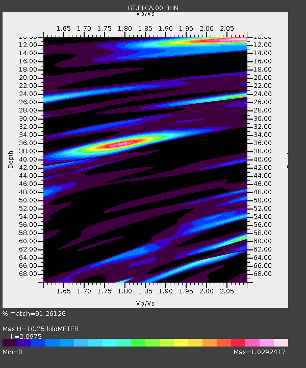
| Estimated Moho Depth: |
10.25 km |
| Estimated Crust Vp/Vs: |
2.10 |
| Assumed Crust Vp: |
6.597 km/s |
| Estimated Crust Vs: |
3.145 km/s |
| Estimated Crust Poisson's Ratio: |
0.35 |
|
| Radial Match: |
91.26126 % |
| Radial Bump: |
292 |
| Transverse Match: |
77.40037 % |
| Transverse Bump: |
400 |
| SOD ConfigId: |
2422 |
| Insert Time: |
2010-02-27 02:15:33.749 +0000 |
| GWidth: |
2.5 |
| Max Bumps: |
400 |
| Tol: |
0.001 |
|

Signal To Noise
| Channel | StoN | STA | LTA |
| GT:PLCA:00:BHN:20051109T11:39:52.99899Z | 22.409845 | 1.7291882E-6 | 7.7161985E-8 |
| GT:PLCA:00:BHE:20051109T11:39:52.99899Z | 11.469837 | 6.3256056E-7 | 5.514992E-8 |
| GT:PLCA:00:BHZ:20051109T11:39:52.99899Z | 37.38652 | 2.7921283E-6 | 7.4682745E-8 |
| Arrivals |
| Ps | 1.8 SECOND |
| PpPs | 4.5 SECOND |
| PsPs/PpSs | 6.3 SECOND |


