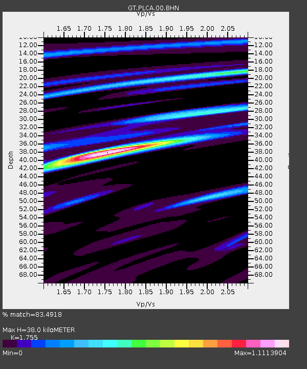
PLCA Paso Flores, Argentina - Earthquake Result Viewer
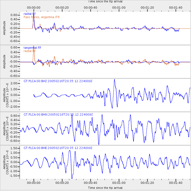
Earthquake location: Southern Mid-Atlantic Ridge
Earthquake latitude/longitude: -36.3/-16.6
Earthquake time(UTC): 2005/02/16 (047) 20:27:52 GMT
Earthquake Depth: 10 km
Earthquake Magnitude: 6.0 MB, 6.1 MS, 6.6 MW, 6.5 MW
Earthquake Catalog/Contributor: WHDF/NEIC
Network: GT Global Telemetered Seismograph Network (USAF/USGS)
Station: PLCA Paso Flores, Argentina
Lat/Lon: 40.73 S/70.55 W
Elevation: 1050 m
Distance: 41.9 deg
Az: 246.955 deg
Baz: 102.055 deg
Ray Param: 0.07348795
Estimated Moho Depth: 38.0 km
Estimated Crust Vp/Vs: 1.75
Assumed Crust Vp: 6.597 km/s
Estimated Crust Vs: 3.759 km/s
Estimated Crust Poisson's Ratio: 0.26
Radial Match: 83.4918 %
Radial Bump: 399
Transverse Match: 60.25128 %
Transverse Bump: 400
SOD ConfigId: 2455
Insert Time: 2010-02-27 02:15:35.570 +0000
GWidth: 2.5
Max Bumps: 400
Tol: 0.001

Signal To Noise

ChannelStoNSTALTA
GT:PLCA:00:BHN:20050216T20:35:12.224009Z0.662938061.1564375E-71.7444125E-7
GT:PLCA:00:BHE:20050216T20:35:12.224009Z3.18399073.5371139E-71.11090586E-7
GT:PLCA:00:BHZ:20050216T20:35:12.224009Z0.54296361.0845105E-71.9973906E-7
Arrivals
Ps4.7 SECOND
PpPs15 SECOND
PsPs/PpSs19 SECOND