You are here: Home > Network List > GT - Global Telemetered Seismograph Network (USAF/USGS) Stations List
> Station PLCA Paso Flores, Argentina > Earthquake Result Viewer
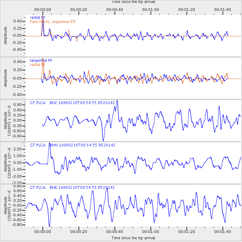
PLCA Paso Flores, Argentina - Earthquake Result Viewer
*The percent match for this event was below the threshold and hence no stack was calculated.
| Earthquake location: |
North Of Ascension Island |
| Earthquake latitude/longitude: |
-1.5/-15.2 |
| Earthquake time(UTC): |
1996/02/16 (047) 09:44:58 GMT |
| Earthquake Depth: |
10 km |
| Earthquake Magnitude: |
6.0 MB, 6.3 MS, 6.5 UNKNOWN, 6.4 MW |
| Earthquake Catalog/Contributor: |
WHDF/NEIC |
|
| Network: |
GT Global Telemetered Seismograph Network (USAF/USGS) |
| Station: |
PLCA Paso Flores, Argentina |
| Lat/Lon: |
40.73 S/70.55 W |
| Elevation: |
1050 m |
|
| Distance: |
63.3 deg |
| Az: |
224.393 deg |
| Baz: |
66.965 deg |
| Ray Param: |
$rayparam |
*The percent match for this event was below the threshold and hence was not used in the summary stack. |
|
| Radial Match: |
76.37542 % |
| Radial Bump: |
400 |
| Transverse Match: |
68.30366 % |
| Transverse Bump: |
400 |
| SOD ConfigId: |
4480 |
| Insert Time: |
2010-02-27 02:15:53.319 +0000 |
| GWidth: |
2.5 |
| Max Bumps: |
400 |
| Tol: |
0.001 |
|
Signal To Noise
| Channel | StoN | STA | LTA |
| GT:PLCA: :BHN:19960216T09:54:55.852014Z | 8.588258 | 1.2131297E-6 | 1.4125446E-7 |
| GT:PLCA: :BHE:19960216T09:54:55.852014Z | 2.4887512 | 3.6221084E-7 | 1.4553919E-7 |
| GT:PLCA: :BHZ:19960216T09:54:55.852014Z | 3.0354714 | 4.919818E-7 | 1.6207757E-7 |
| Arrivals |
| Ps | |
| PpPs | |
| PsPs/PpSs | |


