You are here: Home > Network List > GT - Global Telemetered Seismograph Network (USAF/USGS) Stations List
> Station PLCA Paso Flores, Argentina > Earthquake Result Viewer
PLCA Paso Flores, Argentina - Earthquake Result Viewer
*The percent match for this event was below the threshold and hence no stack was calculated.
| Earthquake location: |
Near Coast Of Chiapas, Mexico |
| Earthquake latitude/longitude: |
16.0/-93.8 |
| Earthquake time(UTC): |
1998/06/07 (158) 23:20:13 GMT |
| Earthquake Depth: |
87 km |
| Earthquake Magnitude: |
5.8 MB, 6.3 UNKNOWN, 6.3 MW |
| Earthquake Catalog/Contributor: |
WHDF/NEIC |
|
| Network: |
GT Global Telemetered Seismograph Network (USAF/USGS) |
| Station: |
PLCA Paso Flores, Argentina |
| Lat/Lon: |
40.73 S/70.55 W |
| Elevation: |
1050 m |
|
| Distance: |
60.4 deg |
| Az: |
159.837 deg |
| Baz: |
334.13 deg |
| Ray Param: |
$rayparam |
*The percent match for this event was below the threshold and hence was not used in the summary stack. |
|
| Radial Match: |
74.944916 % |
| Radial Bump: |
364 |
| Transverse Match: |
60.217495 % |
| Transverse Bump: |
400 |
| SOD ConfigId: |
4480 |
| Insert Time: |
2010-02-27 02:16:00.084 +0000 |
| GWidth: |
2.5 |
| Max Bumps: |
400 |
| Tol: |
0.001 |
|
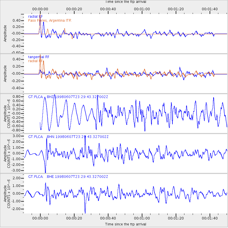
Signal To Noise
| Channel | StoN | STA | LTA |
| GT:PLCA: :BHN:19980607T23:29:43.327002Z | 3.092244 | 1.2590599E-6 | 4.071671E-7 |
| GT:PLCA: :BHE:19980607T23:29:43.327002Z | 2.785405 | 5.3118146E-7 | 1.907017E-7 |
| GT:PLCA: :BHZ:19980607T23:29:43.327002Z | 0.74803096 | 3.515497E-7 | 4.6996675E-7 |
| Arrivals |
| Ps | |
| PpPs | |
| PsPs/PpSs | |


