You are here: Home > Network List > GT - Global Telemetered Seismograph Network (USAF/USGS) Stations List
> Station PLCA Paso Flores, Argentina > Earthquake Result Viewer
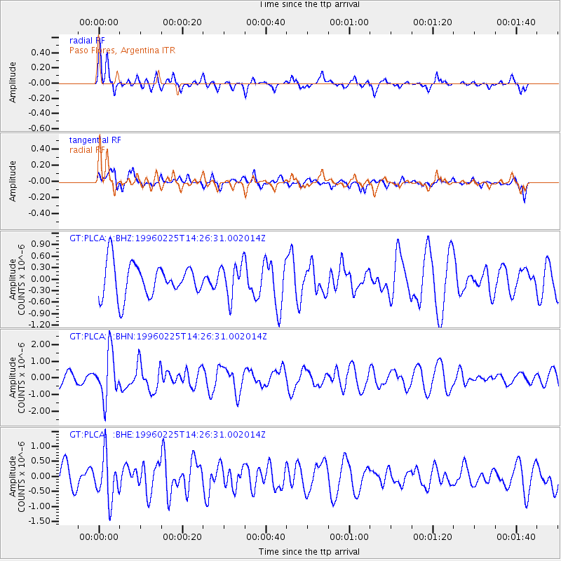
PLCA Paso Flores, Argentina - Earthquake Result Viewer
*The percent match for this event was below the threshold and hence no stack was calculated.
| Earthquake location: |
Near Coast Of Guatemala |
| Earthquake latitude/longitude: |
13.0/-91.1 |
| Earthquake time(UTC): |
1996/02/25 (056) 14:17:21 GMT |
| Earthquake Depth: |
33 km |
| Earthquake Magnitude: |
5.5 MB, 5.2 MS, 5.9 UNKNOWN, 5.8 MW |
| Earthquake Catalog/Contributor: |
WHDF/NEIC |
|
| Network: |
GT Global Telemetered Seismograph Network (USAF/USGS) |
| Station: |
PLCA Paso Flores, Argentina |
| Lat/Lon: |
40.73 S/70.55 W |
| Elevation: |
1050 m |
|
| Distance: |
56.8 deg |
| Az: |
161.446 deg |
| Baz: |
335.915 deg |
| Ray Param: |
$rayparam |
*The percent match for this event was below the threshold and hence was not used in the summary stack. |
|
| Radial Match: |
67.58348 % |
| Radial Bump: |
400 |
| Transverse Match: |
57.358654 % |
| Transverse Bump: |
373 |
| SOD ConfigId: |
4480 |
| Insert Time: |
2010-02-27 02:16:03.010 +0000 |
| GWidth: |
2.5 |
| Max Bumps: |
400 |
| Tol: |
0.001 |
|
Signal To Noise
| Channel | StoN | STA | LTA |
| GT:PLCA: :BHN:19960225T14:26:31.002014Z | 3.556547 | 1.4060608E-6 | 3.9534441E-7 |
| GT:PLCA: :BHE:19960225T14:26:31.002014Z | 2.0183234 | 7.518965E-7 | 3.7253517E-7 |
| GT:PLCA: :BHZ:19960225T14:26:31.002014Z | 1.0336705 | 4.4865524E-7 | 4.3404083E-7 |
| Arrivals |
| Ps | |
| PpPs | |
| PsPs/PpSs | |


