You are here: Home > Network List > GT - Global Telemetered Seismograph Network (USAF/USGS) Stations List
> Station PLCA Paso Flores, Argentina > Earthquake Result Viewer
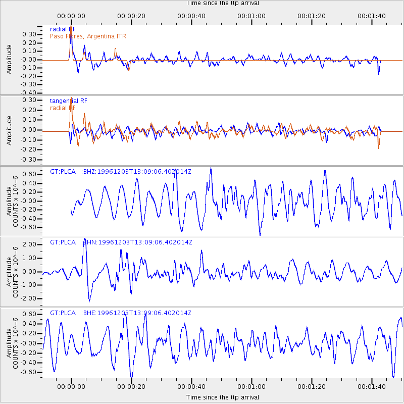
PLCA Paso Flores, Argentina - Earthquake Result Viewer
*The percent match for this event was below the threshold and hence no stack was calculated.
| Earthquake location: |
Tonga Islands Region |
| Earthquake latitude/longitude: |
-18.4/-172.3 |
| Earthquake time(UTC): |
1996/12/03 (338) 12:56:56 GMT |
| Earthquake Depth: |
33 km |
| Earthquake Magnitude: |
6.0 MB, 6.0 MS, 6.1 UNKNOWN, 6.1 MW |
| Earthquake Catalog/Contributor: |
WHDF/NEIC |
|
| Network: |
GT Global Telemetered Seismograph Network (USAF/USGS) |
| Station: |
PLCA Paso Flores, Argentina |
| Lat/Lon: |
40.73 S/70.55 W |
| Elevation: |
1050 m |
|
| Distance: |
86.7 deg |
| Az: |
131.818 deg |
| Baz: |
248.664 deg |
| Ray Param: |
$rayparam |
*The percent match for this event was below the threshold and hence was not used in the summary stack. |
|
| Radial Match: |
65.622345 % |
| Radial Bump: |
400 |
| Transverse Match: |
44.20576 % |
| Transverse Bump: |
400 |
| SOD ConfigId: |
4480 |
| Insert Time: |
2010-02-27 02:16:09.265 +0000 |
| GWidth: |
2.5 |
| Max Bumps: |
400 |
| Tol: |
0.001 |
|
Signal To Noise
| Channel | StoN | STA | LTA |
| GT:PLCA: :BHN:19961203T13:09:06.402014Z | 3.5618074 | 1.0246762E-6 | 2.8768434E-7 |
| GT:PLCA: :BHE:19961203T13:09:06.402014Z | 0.79055226 | 1.8845488E-7 | 2.3838383E-7 |
| GT:PLCA: :BHZ:19961203T13:09:06.402014Z | 1.3639745 | 3.4868896E-7 | 2.5564185E-7 |
| Arrivals |
| Ps | |
| PpPs | |
| PsPs/PpSs | |


