You are here: Home > Network List > G - GEOSCOPE Stations List
> Station TAM Tamanrasset, Algeria > Earthquake Result Viewer
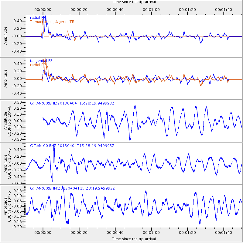
TAM Tamanrasset, Algeria - Earthquake Result Viewer
*The percent match for this event was below the threshold and hence no stack was calculated.
| Earthquake location: |
Myanmar |
| Earthquake latitude/longitude: |
19.2/95.7 |
| Earthquake time(UTC): |
2013/04/04 (094) 15:16:26 GMT |
| Earthquake Depth: |
11 km |
| Earthquake Magnitude: |
5.6 MB |
| Earthquake Catalog/Contributor: |
NEIC PDE/NEIC PDE-W |
|
| Network: |
G GEOSCOPE |
| Station: |
TAM Tamanrasset, Algeria |
| Lat/Lon: |
22.79 N/5.53 E |
| Elevation: |
1377 m |
|
| Distance: |
82.9 deg |
| Az: |
291.582 deg |
| Baz: |
72.176 deg |
| Ray Param: |
$rayparam |
*The percent match for this event was below the threshold and hence was not used in the summary stack. |
|
| Radial Match: |
65.00034 % |
| Radial Bump: |
400 |
| Transverse Match: |
55.511227 % |
| Transverse Bump: |
400 |
| SOD ConfigId: |
512006 |
| Insert Time: |
2013-09-05 15:42:28.356 +0000 |
| GWidth: |
2.5 |
| Max Bumps: |
400 |
| Tol: |
0.001 |
|
Signal To Noise
| Channel | StoN | STA | LTA |
| G:TAM:00:BHZ:20130404T15:28:19.949993Z | 1.5321236 | 1.5809125E-7 | 1.03184405E-7 |
| G:TAM:00:BHN:20130404T15:28:19.949993Z | 1.056938 | 5.2234007E-8 | 4.942012E-8 |
| G:TAM:00:BHE:20130404T15:28:19.949993Z | 1.7183721 | 1.326544E-7 | 7.7197726E-8 |
| Arrivals |
| Ps | |
| PpPs | |
| PsPs/PpSs | |


