You are here: Home > Network List > II - Global Seismograph Network (GSN - IRIS/IDA) Stations List
> Station WRAB Tennant Creek, NT, Australia > Earthquake Result Viewer
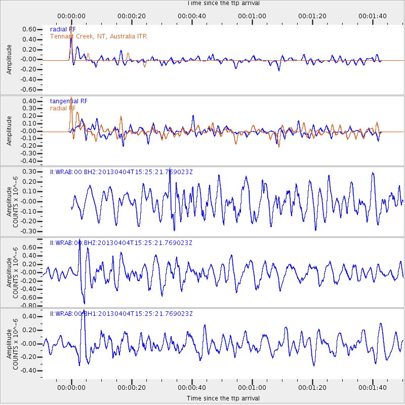
WRAB Tennant Creek, NT, Australia - Earthquake Result Viewer
*The percent match for this event was below the threshold and hence no stack was calculated.
| Earthquake location: |
Myanmar |
| Earthquake latitude/longitude: |
19.2/95.7 |
| Earthquake time(UTC): |
2013/04/04 (094) 15:16:26 GMT |
| Earthquake Depth: |
11 km |
| Earthquake Magnitude: |
5.6 MB |
| Earthquake Catalog/Contributor: |
NEIC PDE/NEIC PDE-W |
|
| Network: |
II Global Seismograph Network (GSN - IRIS/IDA) |
| Station: |
WRAB Tennant Creek, NT, Australia |
| Lat/Lon: |
19.93 S/134.36 E |
| Elevation: |
366 m |
|
| Distance: |
54.3 deg |
| Az: |
133.699 deg |
| Baz: |
313.445 deg |
| Ray Param: |
$rayparam |
*The percent match for this event was below the threshold and hence was not used in the summary stack. |
|
| Radial Match: |
51.444378 % |
| Radial Bump: |
400 |
| Transverse Match: |
60.38995 % |
| Transverse Bump: |
400 |
| SOD ConfigId: |
512006 |
| Insert Time: |
2013-09-05 15:44:08.988 +0000 |
| GWidth: |
2.5 |
| Max Bumps: |
400 |
| Tol: |
0.001 |
|
Signal To Noise
| Channel | StoN | STA | LTA |
| II:WRAB:00:BHZ:20130404T15:25:21.769023Z | 2.786401 | 3.4519704E-7 | 1.2388634E-7 |
| II:WRAB:00:BH1:20130404T15:25:21.769023Z | 2.0512676 | 2.3638592E-7 | 1.1523895E-7 |
| II:WRAB:00:BH2:20130404T15:25:21.769023Z | 1.4781889 | 1.5655371E-7 | 1.05909145E-7 |
| Arrivals |
| Ps | |
| PpPs | |
| PsPs/PpSs | |


