You are here: Home > Network List > IU - Global Seismograph Network (GSN - IRIS/USGS) Stations List
> Station HNR Honiara, Solomon Islands > Earthquake Result Viewer
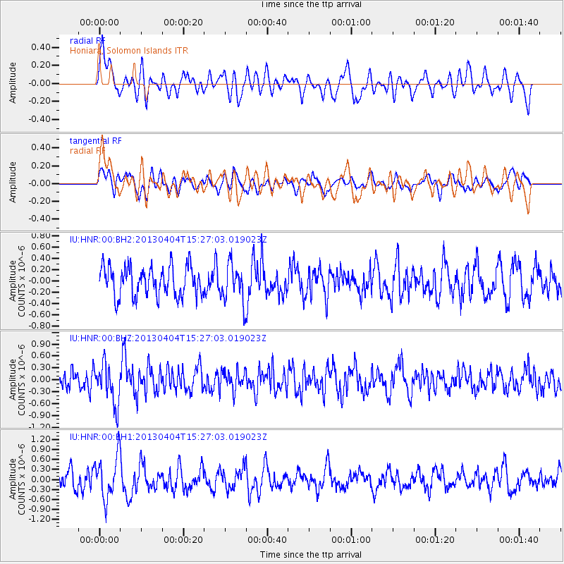
HNR Honiara, Solomon Islands - Earthquake Result Viewer
*The percent match for this event was below the threshold and hence no stack was calculated.
| Earthquake location: |
Myanmar |
| Earthquake latitude/longitude: |
19.2/95.7 |
| Earthquake time(UTC): |
2013/04/04 (094) 15:16:26 GMT |
| Earthquake Depth: |
11 km |
| Earthquake Magnitude: |
5.6 MB |
| Earthquake Catalog/Contributor: |
NEIC PDE/NEIC PDE-W |
|
| Network: |
IU Global Seismograph Network (GSN - IRIS/USGS) |
| Station: |
HNR Honiara, Solomon Islands |
| Lat/Lon: |
9.44 S/159.95 E |
| Elevation: |
100 m |
|
| Distance: |
69.4 deg |
| Az: |
108.349 deg |
| Baz: |
294.646 deg |
| Ray Param: |
$rayparam |
*The percent match for this event was below the threshold and hence was not used in the summary stack. |
|
| Radial Match: |
48.313145 % |
| Radial Bump: |
400 |
| Transverse Match: |
49.141136 % |
| Transverse Bump: |
400 |
| SOD ConfigId: |
512006 |
| Insert Time: |
2013-09-05 15:44:35.602 +0000 |
| GWidth: |
2.5 |
| Max Bumps: |
400 |
| Tol: |
0.001 |
|
Signal To Noise
| Channel | StoN | STA | LTA |
| IU:HNR:00:BHZ:20130404T15:27:03.019023Z | 2.1117406 | 5.141216E-7 | 2.434587E-7 |
| IU:HNR:00:BH1:20130404T15:27:03.019023Z | 2.3361201 | 6.493699E-7 | 2.779694E-7 |
| IU:HNR:00:BH2:20130404T15:27:03.019023Z | 1.2836275 | 3.381606E-7 | 2.6344136E-7 |
| Arrivals |
| Ps | |
| PpPs | |
| PsPs/PpSs | |


