You are here: Home > Network List > GT - Global Telemetered Seismograph Network (USAF/USGS) Stations List
> Station PLCA Paso Flores, Argentina > Earthquake Result Viewer
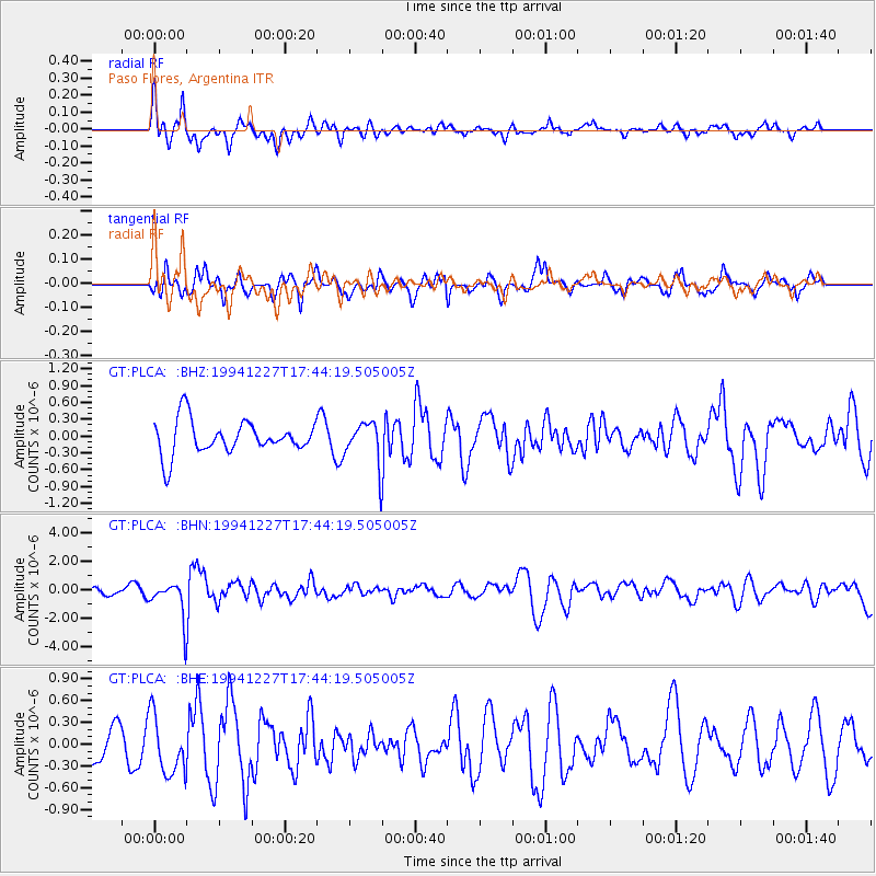
PLCA Paso Flores, Argentina - Earthquake Result Viewer
*The percent match for this event was below the threshold and hence no stack was calculated.
| Earthquake location: |
South Of Kermadec Islands |
| Earthquake latitude/longitude: |
-32.0/179.9 |
| Earthquake time(UTC): |
1994/12/27 (361) 17:32:52 GMT |
| Earthquake Depth: |
228 km |
| Earthquake Magnitude: |
6.0 MB, 6.1 UNKNOWN, 6.4 MW |
| Earthquake Catalog/Contributor: |
WHDF/NEIC |
|
| Network: |
GT Global Telemetered Seismograph Network (USAF/USGS) |
| Station: |
PLCA Paso Flores, Argentina |
| Lat/Lon: |
40.73 S/70.55 W |
| Elevation: |
1050 m |
|
| Distance: |
82.7 deg |
| Az: |
133.797 deg |
| Baz: |
233.803 deg |
| Ray Param: |
$rayparam |
*The percent match for this event was below the threshold and hence was not used in the summary stack. |
|
| Radial Match: |
73.69119 % |
| Radial Bump: |
367 |
| Transverse Match: |
49.98629 % |
| Transverse Bump: |
364 |
| SOD ConfigId: |
4480 |
| Insert Time: |
2010-02-27 02:16:18.023 +0000 |
| GWidth: |
2.5 |
| Max Bumps: |
400 |
| Tol: |
0.001 |
|
Signal To Noise
| Channel | StoN | STA | LTA |
| GT:PLCA: :BHN:19941227T17:44:19.505005Z | 4.223668 | 1.3475639E-6 | 3.1905063E-7 |
| GT:PLCA: :BHE:19941227T17:44:19.505005Z | 1.8280854 | 4.0578323E-7 | 2.219717E-7 |
| GT:PLCA: :BHZ:19941227T17:44:19.505005Z | 1.2430933 | 3.6938567E-7 | 2.9715042E-7 |
| Arrivals |
| Ps | |
| PpPs | |
| PsPs/PpSs | |


