You are here: Home > Network List > GT - Global Telemetered Seismograph Network (USAF/USGS) Stations List
> Station PLCA Paso Flores, Argentina > Earthquake Result Viewer
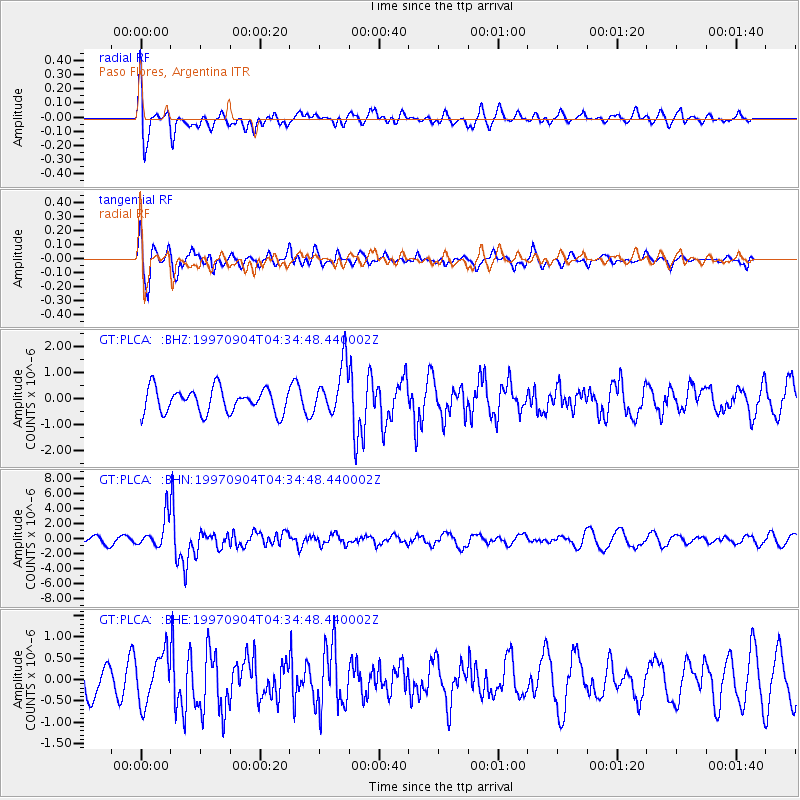
PLCA Paso Flores, Argentina - Earthquake Result Viewer
*The percent match for this event was below the threshold and hence no stack was calculated.
| Earthquake location: |
South Of Fiji Islands |
| Earthquake latitude/longitude: |
-26.6/178.3 |
| Earthquake time(UTC): |
1997/09/04 (247) 04:23:37 GMT |
| Earthquake Depth: |
625 km |
| Earthquake Magnitude: |
6.3 MB, 6.8 UNKNOWN, 6.5 ME |
| Earthquake Catalog/Contributor: |
WHDF/NEIC |
|
| Network: |
GT Global Telemetered Seismograph Network (USAF/USGS) |
| Station: |
PLCA Paso Flores, Argentina |
| Lat/Lon: |
40.73 S/70.55 W |
| Elevation: |
1050 m |
|
| Distance: |
87.5 deg |
| Az: |
134.798 deg |
| Baz: |
236.75 deg |
| Ray Param: |
$rayparam |
*The percent match for this event was below the threshold and hence was not used in the summary stack. |
|
| Radial Match: |
64.88394 % |
| Radial Bump: |
400 |
| Transverse Match: |
60.0888 % |
| Transverse Bump: |
400 |
| SOD ConfigId: |
4480 |
| Insert Time: |
2010-02-27 02:16:52.940 +0000 |
| GWidth: |
2.5 |
| Max Bumps: |
400 |
| Tol: |
0.001 |
|
Signal To Noise
| Channel | StoN | STA | LTA |
| GT:PLCA: :BHN:19970904T04:34:48.440002Z | 4.7136736 | 2.0240714E-6 | 4.2940422E-7 |
| GT:PLCA: :BHE:19970904T04:34:48.440002Z | 1.1604118 | 5.693514E-7 | 4.9064596E-7 |
| GT:PLCA: :BHZ:19970904T04:34:48.440002Z | 2.0699847 | 9.696673E-7 | 4.6844175E-7 |
| Arrivals |
| Ps | |
| PpPs | |
| PsPs/PpSs | |


