You are here: Home > Network List > GT - Global Telemetered Seismograph Network (USAF/USGS) Stations List
> Station PLCA Paso Flores, Argentina > Earthquake Result Viewer
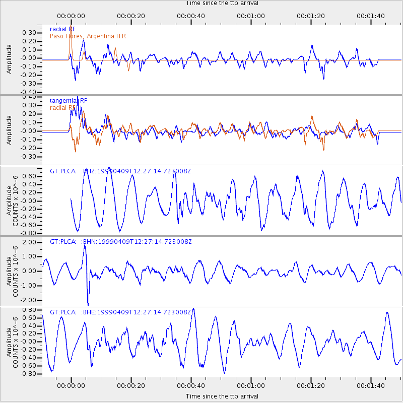
PLCA Paso Flores, Argentina - Earthquake Result Viewer
*The percent match for this event was below the threshold and hence no stack was calculated.
| Earthquake location: |
South Of Fiji Islands |
| Earthquake latitude/longitude: |
-26.4/178.2 |
| Earthquake time(UTC): |
1999/04/09 (099) 12:16:01 GMT |
| Earthquake Depth: |
621 km |
| Earthquake Magnitude: |
5.5 MB, 6.2 MW, 6.1 MW |
| Earthquake Catalog/Contributor: |
WHDF/NEIC |
|
| Network: |
GT Global Telemetered Seismograph Network (USAF/USGS) |
| Station: |
PLCA Paso Flores, Argentina |
| Lat/Lon: |
40.73 S/70.55 W |
| Elevation: |
1050 m |
|
| Distance: |
87.7 deg |
| Az: |
134.852 deg |
| Baz: |
236.829 deg |
| Ray Param: |
$rayparam |
*The percent match for this event was below the threshold and hence was not used in the summary stack. |
|
| Radial Match: |
73.92093 % |
| Radial Bump: |
400 |
| Transverse Match: |
69.19999 % |
| Transverse Bump: |
400 |
| SOD ConfigId: |
4480 |
| Insert Time: |
2010-02-27 02:16:53.840 +0000 |
| GWidth: |
2.5 |
| Max Bumps: |
400 |
| Tol: |
0.001 |
|
Signal To Noise
| Channel | StoN | STA | LTA |
| GT:PLCA: :BHN:19990409T12:27:14.723008Z | 1.6943194 | 7.3662574E-7 | 4.3476203E-7 |
| GT:PLCA: :BHE:19990409T12:27:14.723008Z | 0.7180234 | 3.2040796E-7 | 4.462361E-7 |
| GT:PLCA: :BHZ:19990409T12:27:14.723008Z | 0.7166968 | 3.5050238E-7 | 4.8905247E-7 |
| Arrivals |
| Ps | |
| PpPs | |
| PsPs/PpSs | |


