You are here: Home > Network List > CI - Caltech Regional Seismic Network Stations List
> Station SLA SLA, Trona, CA, USA > Earthquake Result Viewer
SLA SLA, Trona, CA, USA - Earthquake Result Viewer
| Earthquake location: |
Kermadec Islands, New Zealand |
| Earthquake latitude/longitude: |
-29.7/-178.6 |
| Earthquake time(UTC): |
2001/06/03 (154) 02:41:57 GMT |
| Earthquake Depth: |
178 km |
| Earthquake Magnitude: |
6.8 MB, 7.2 MW, 7.1 MW |
| Earthquake Catalog/Contributor: |
WHDF/NEIC |
|
| Network: |
CI Caltech Regional Seismic Network |
| Station: |
SLA SLA, Trona, CA, USA |
| Lat/Lon: |
35.89 N/117.28 W |
| Elevation: |
1174 m |
|
| Distance: |
87.1 deg |
| Az: |
45.522 deg |
| Baz: |
229.889 deg |
| Ray Param: |
0.043200485 |
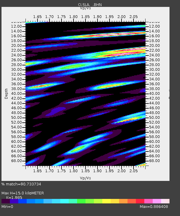
| Estimated Moho Depth: |
15.0 km |
| Estimated Crust Vp/Vs: |
1.99 |
| Assumed Crust Vp: |
6.276 km/s |
| Estimated Crust Vs: |
3.162 km/s |
| Estimated Crust Poisson's Ratio: |
0.33 |
|
| Radial Match: |
90.733734 % |
| Radial Bump: |
400 |
| Transverse Match: |
92.227516 % |
| Transverse Bump: |
400 |
| SOD ConfigId: |
3787 |
| Insert Time: |
2010-02-25 20:29:16.765 +0000 |
| GWidth: |
2.5 |
| Max Bumps: |
400 |
| Tol: |
0.001 |
|
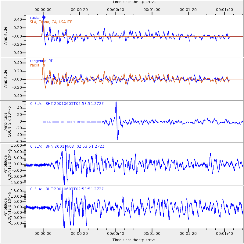
Signal To Noise
| Channel | StoN | STA | LTA |
| CI:SLA: :BHN:20010603T02:53:51.272Z | 0.981992 | 6.545628E-7 | 6.6656634E-7 |
| CI:SLA: :BHE:20010603T02:53:51.272Z | 1.100741 | 8.278815E-7 | 7.5211284E-7 |
| CI:SLA: :BHZ:20010603T02:53:51.272Z | 5.9061575 | 1.7097055E-6 | 2.894785E-7 |
| Arrivals |
| Ps | 2.4 SECOND |
| PpPs | 7.0 SECOND |
| PsPs/PpSs | 9.4 SECOND |


