You are here: Home > Network List > GT - Global Telemetered Seismograph Network (USAF/USGS) Stations List
> Station SBA Scott Base, Antarctica > Earthquake Result Viewer
SBA Scott Base, Antarctica - Earthquake Result Viewer
| Earthquake location: |
Solomon Islands |
| Earthquake latitude/longitude: |
-6.5/155.0 |
| Earthquake time(UTC): |
1996/04/29 (120) 14:40:41 GMT |
| Earthquake Depth: |
44 km |
| Earthquake Magnitude: |
6.3 MB, 7.5 MS, 7.2 UNKNOWN, 6.8 ME |
| Earthquake Catalog/Contributor: |
WHDF/NEIC |
|
| Network: |
GT Global Telemetered Seismograph Network (USAF/USGS) |
| Station: |
SBA Scott Base, Antarctica |
| Lat/Lon: |
77.85 S/166.76 E |
| Elevation: |
20 m |
|
| Distance: |
71.6 deg |
| Az: |
177.392 deg |
| Baz: |
347.676 deg |
| Ray Param: |
0.0541647 |
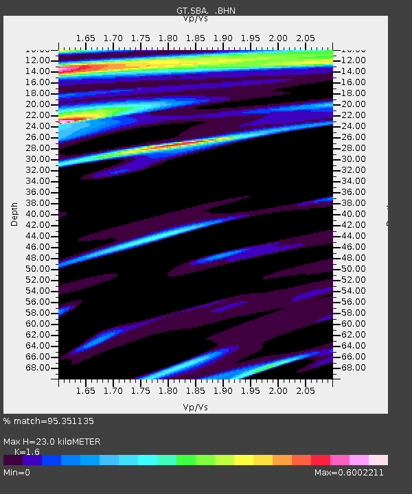
| Estimated Moho Depth: |
23.0 km |
| Estimated Crust Vp/Vs: |
1.60 |
| Assumed Crust Vp: |
6.183 km/s |
| Estimated Crust Vs: |
3.864 km/s |
| Estimated Crust Poisson's Ratio: |
0.18 |
|
| Radial Match: |
95.351135 % |
| Radial Bump: |
362 |
| Transverse Match: |
81.98421 % |
| Transverse Bump: |
308 |
| SOD ConfigId: |
6273 |
| Insert Time: |
2010-02-27 02:18:27.361 +0000 |
| GWidth: |
2.5 |
| Max Bumps: |
400 |
| Tol: |
0.001 |
|

Signal To Noise
| Channel | StoN | STA | LTA |
| GT:SBA: :BHN:19960429T14:51:26.666016Z | 2.9400306 | 1.6664069E-6 | 5.667992E-7 |
| GT:SBA: :BHE:19960429T14:51:26.666016Z | 0.87966156 | 6.252338E-7 | 7.1076624E-7 |
| GT:SBA: :BHZ:19960429T14:51:26.666016Z | 12.052417 | 6.1650812E-6 | 5.115224E-7 |
| Arrivals |
| Ps | 2.3 SECOND |
| PpPs | 9.3 SECOND |
| PsPs/PpSs | 12 SECOND |


