You are here: Home > Network List > G - GEOSCOPE Stations List
> Station ATD Arta Cave - Arta, Republic of Djibouti > Earthquake Result Viewer
ATD Arta Cave - Arta, Republic of Djibouti - Earthquake Result Viewer
| Earthquake location: |
Southwest Indian Ridge |
| Earthquake latitude/longitude: |
-40.4/45.4 |
| Earthquake time(UTC): |
2013/04/02 (092) 14:34:55 GMT |
| Earthquake Depth: |
9.0 km |
| Earthquake Magnitude: |
5.9 MW, 5.8 MS, 5.8 MW, 5.9 MB |
| Earthquake Catalog/Contributor: |
NEIC PDE/NEIC PDE-W |
|
| Network: |
G GEOSCOPE |
| Station: |
ATD Arta Cave - Arta, Republic of Djibouti |
| Lat/Lon: |
11.53 N/42.85 E |
| Elevation: |
610 m |
|
| Distance: |
51.8 deg |
| Az: |
356.836 deg |
| Baz: |
177.537 deg |
| Ray Param: |
0.06720229 |
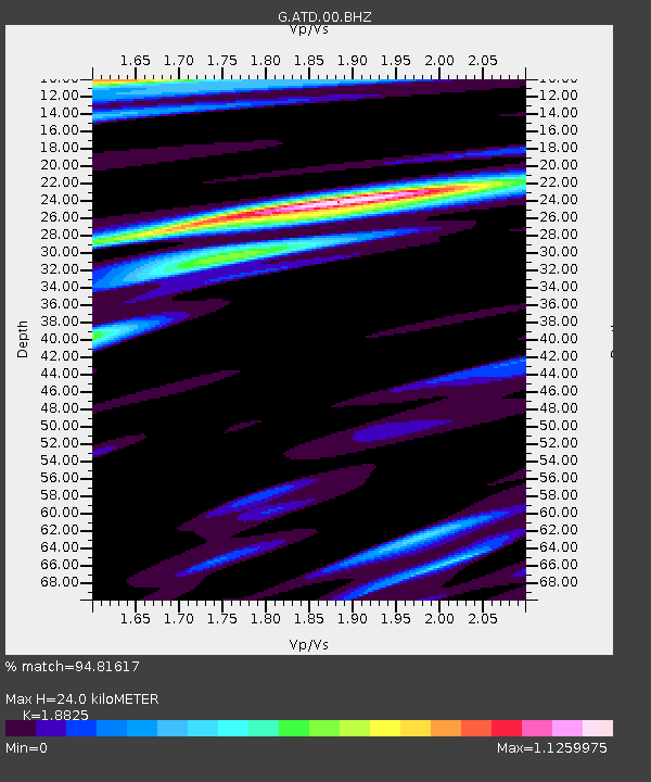
| Estimated Moho Depth: |
24.0 km |
| Estimated Crust Vp/Vs: |
1.88 |
| Assumed Crust Vp: |
6.375 km/s |
| Estimated Crust Vs: |
3.386 km/s |
| Estimated Crust Poisson's Ratio: |
0.30 |
|
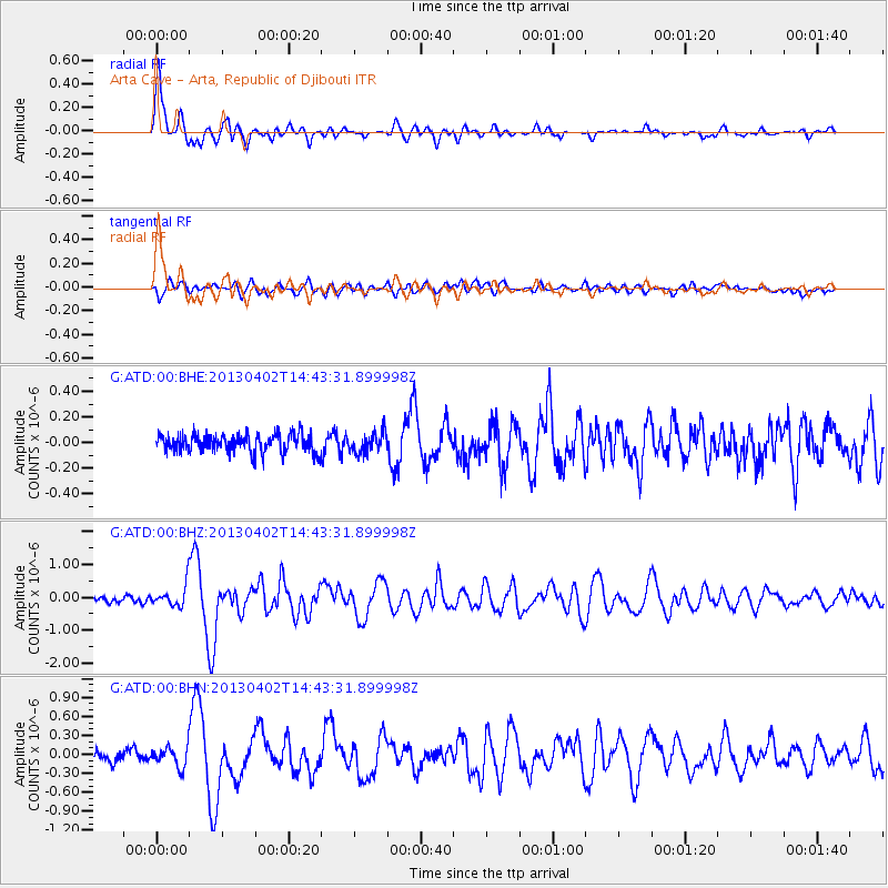
| Radial Match: |
94.81617 % |
| Radial Bump: |
380 |
| Transverse Match: |
79.52837 % |
| Transverse Bump: |
400 |
| SOD ConfigId: |
512894 |
| Insert Time: |
2013-09-12 23:19:33.726 +0000 |
| GWidth: |
2.5 |
| Max Bumps: |
400 |
| Tol: |
0.001 |
|
Signal To Noise
| Channel | StoN | STA | LTA |
| G:ATD:00:BHZ:20130402T14:43:31.899998Z | 3.1902292 | 3.2283756E-7 | 1.01195724E-7 |
| G:ATD:00:BHN:20130402T14:43:31.899998Z | 2.313472 | 1.5402804E-7 | 6.6578735E-8 |
| G:ATD:00:BHE:20130402T14:43:31.899998Z | 1.100444 | 7.8806345E-8 | 7.161323E-8 |
| Arrivals |
| Ps | 3.5 SECOND |
| PpPs | 10 SECOND |
| PsPs/PpSs | 14 SECOND |


