You are here: Home > Network List > GT - Global Telemetered Seismograph Network (USAF/USGS) Stations List
> Station SBA Scott Base, Antarctica > Earthquake Result Viewer
SBA Scott Base, Antarctica - Earthquake Result Viewer
| Earthquake location: |
Easter Island Region |
| Earthquake latitude/longitude: |
-22.1/-113.4 |
| Earthquake time(UTC): |
1996/09/05 (249) 08:14:14 GMT |
| Earthquake Depth: |
10 km |
| Earthquake Magnitude: |
6.2 MB, 7.0 MS, 7.0 UNKNOWN, 6.9 MW |
| Earthquake Catalog/Contributor: |
WHDF/NEIC |
|
| Network: |
GT Global Telemetered Seismograph Network (USAF/USGS) |
| Station: |
SBA Scott Base, Antarctica |
| Lat/Lon: |
77.85 S/166.76 E |
| Elevation: |
20 m |
|
| Distance: |
66.4 deg |
| Az: |
193.153 deg |
| Baz: |
84.924 deg |
| Ray Param: |
0.057652187 |
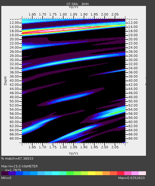
| Estimated Moho Depth: |
15.0 km |
| Estimated Crust Vp/Vs: |
1.80 |
| Assumed Crust Vp: |
6.183 km/s |
| Estimated Crust Vs: |
3.44 km/s |
| Estimated Crust Poisson's Ratio: |
0.28 |
|
| Radial Match: |
87.36533 % |
| Radial Bump: |
400 |
| Transverse Match: |
82.748566 % |
| Transverse Bump: |
394 |
| SOD ConfigId: |
6273 |
| Insert Time: |
2010-02-27 02:18:49.833 +0000 |
| GWidth: |
2.5 |
| Max Bumps: |
400 |
| Tol: |
0.001 |
|
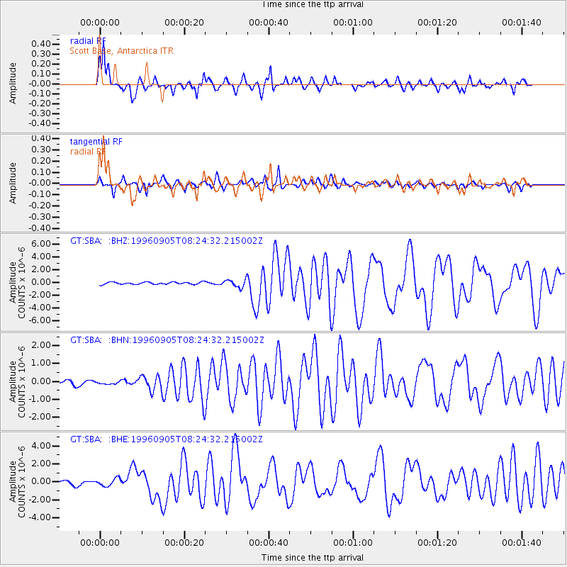
Signal To Noise
| Channel | StoN | STA | LTA |
| GT:SBA: :BHN:19960905T08:24:32.215002Z | 0.42021573 | 7.4888455E-8 | 1.7821431E-7 |
| GT:SBA: :BHE:19960905T08:24:32.215002Z | 1.455722 | 4.304242E-7 | 2.9567747E-7 |
| GT:SBA: :BHZ:19960905T08:24:32.215002Z | 3.53743 | 6.0148454E-7 | 1.7003434E-7 |
| Arrivals |
| Ps | 2.0 SECOND |
| PpPs | 6.5 SECOND |
| PsPs/PpSs | 8.5 SECOND |


