You are here: Home > Network List > GT - Global Telemetered Seismograph Network (USAF/USGS) Stations List
> Station SBA Scott Base, Antarctica > Earthquake Result Viewer
SBA Scott Base, Antarctica - Earthquake Result Viewer

| Earthquake location: |
Solomon Islands |
| Earthquake latitude/longitude: |
-7.1/155.6 |
| Earthquake time(UTC): |
1996/10/14 (288) 23:26:20 GMT |
| Earthquake Depth: |
24 km |
| Earthquake Magnitude: |
5.9 MB, 6.9 MS, 6.8 UNKNOWN, 6.3 ME |
| Earthquake Catalog/Contributor: |
WHDF/NEIC |
|
| Network: |
GT Global Telemetered Seismograph Network (USAF/USGS) |
| Station: |
SBA Scott Base, Antarctica |
| Lat/Lon: |
77.85 S/166.76 E |
| Elevation: |
20 m |
|
| Distance: |
70.9 deg |
| Az: |
177.507 deg |
| Baz: |
348.243 deg |
| Ray Param: |
0.05463 |
| Estimated Moho Depth: |
14.25 km |
| Estimated Crust Vp/Vs: |
1.60 |
| Assumed Crust Vp: |
6.183 km/s |
| Estimated Crust Vs: |
3.864 km/s |
| Estimated Crust Poisson's Ratio: |
0.18 |
|
| Radial Match: |
95.230934 % |
| Radial Bump: |
382 |
| Transverse Match: |
80.49545 % |
| Transverse Bump: |
400 |
| SOD ConfigId: |
6273 |
| Insert Time: |
2010-02-27 02:18:54.183 +0000 |
| GWidth: |
2.5 |
| Max Bumps: |
400 |
| Tol: |
0.001 |
|
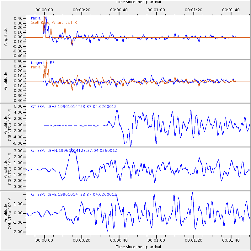
Signal To Noise
| Channel | StoN | STA | LTA |
| GT:SBA: :BHN:19961014T23:37:04.026001Z | 1.3256583 | 1.9077099E-7 | 1.439066E-7 |
| GT:SBA: :BHE:19961014T23:37:04.026001Z | 2.414366 | 2.0814066E-7 | 8.620924E-8 |
| GT:SBA: :BHZ:19961014T23:37:04.026001Z | 4.1518836 | 4.3676846E-7 | 1.05197664E-7 |
| Arrivals |
| Ps | 1.4 SECOND |
| PpPs | 5.8 SECOND |
| PsPs/PpSs | 7.2 SECOND |


