You are here: Home > Network List > IU - Global Seismograph Network (GSN - IRIS/USGS) Stations List
> Station PMG Port Moresby, New Guinea > Earthquake Result Viewer
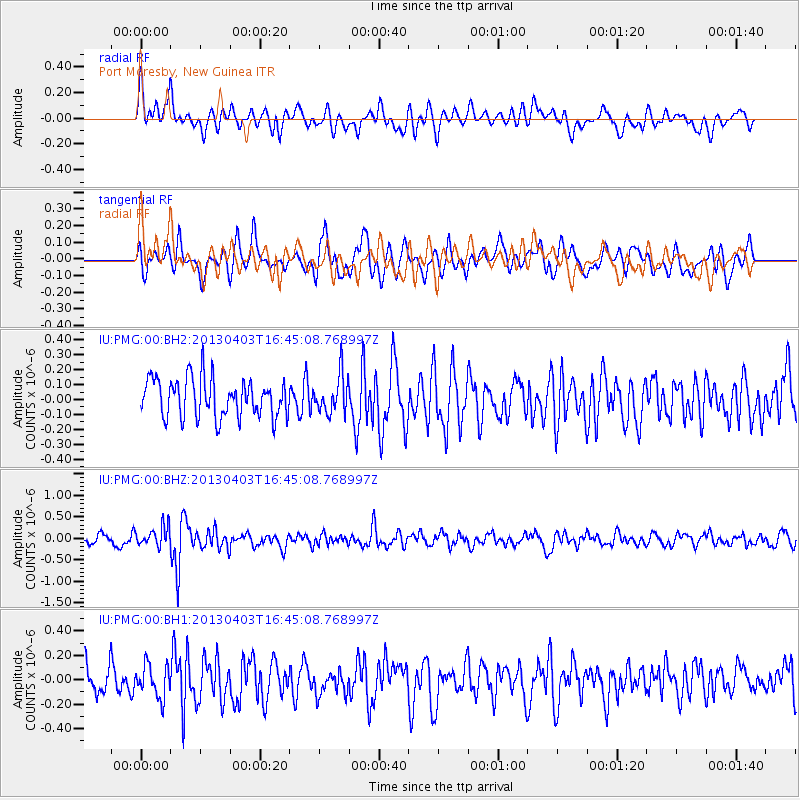
PMG Port Moresby, New Guinea - Earthquake Result Viewer
*The percent match for this event was below the threshold and hence no stack was calculated.
| Earthquake location: |
Myanmar |
| Earthquake latitude/longitude: |
19.2/95.6 |
| Earthquake time(UTC): |
2013/04/03 (093) 16:35:45 GMT |
| Earthquake Depth: |
6.0 km |
| Earthquake Magnitude: |
5.8 MB |
| Earthquake Catalog/Contributor: |
NEIC PDE/NEIC PDE-W |
|
| Network: |
IU Global Seismograph Network (GSN - IRIS/USGS) |
| Station: |
PMG Port Moresby, New Guinea |
| Lat/Lon: |
9.40 S/147.16 E |
| Elevation: |
90 m |
|
| Distance: |
58.2 deg |
| Az: |
114.646 deg |
| Baz: |
299.496 deg |
| Ray Param: |
$rayparam |
*The percent match for this event was below the threshold and hence was not used in the summary stack. |
|
| Radial Match: |
59.78787 % |
| Radial Bump: |
400 |
| Transverse Match: |
60.803673 % |
| Transverse Bump: |
400 |
| SOD ConfigId: |
512894 |
| Insert Time: |
2013-09-12 23:40:37.365 +0000 |
| GWidth: |
2.5 |
| Max Bumps: |
400 |
| Tol: |
0.001 |
|
Signal To Noise
| Channel | StoN | STA | LTA |
| IU:PMG:00:BHZ:20130403T16:45:08.768997Z | 1.9587892 | 2.2123399E-7 | 1.1294426E-7 |
| IU:PMG:00:BH1:20130403T16:45:08.768997Z | 1.1911821 | 1.334369E-7 | 1.12020565E-7 |
| IU:PMG:00:BH2:20130403T16:45:08.768997Z | 0.97540677 | 1.2515859E-7 | 1.2831426E-7 |
| Arrivals |
| Ps | |
| PpPs | |
| PsPs/PpSs | |


