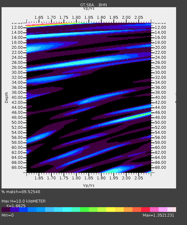
SBA Scott Base, Antarctica - Earthquake Result Viewer
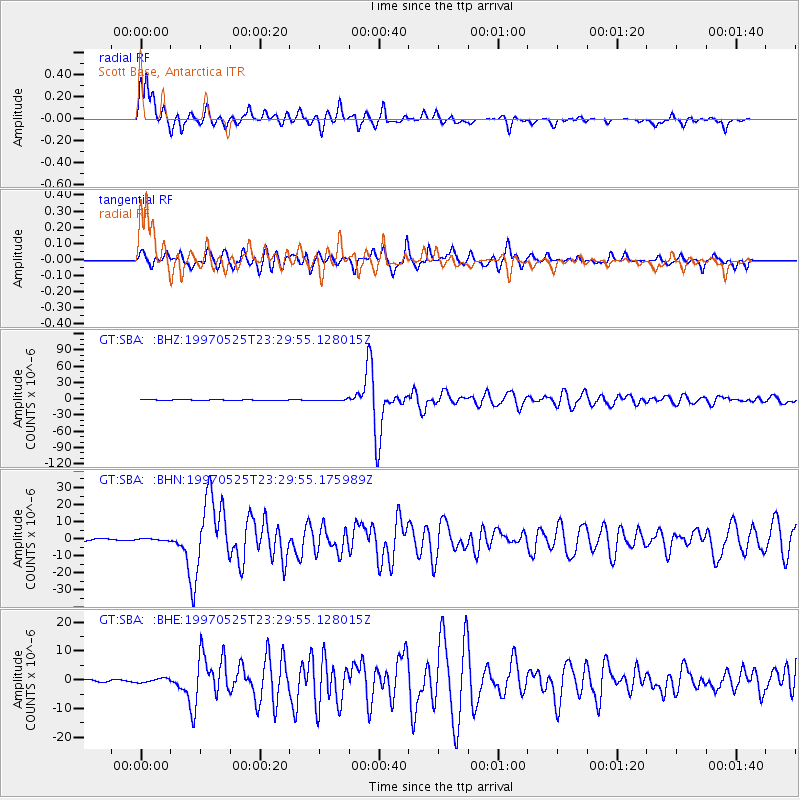
Earthquake location: South Of Kermadec Islands
Earthquake latitude/longitude: -32.1/179.8
Earthquake time(UTC): 1997/05/25 (145) 23:22:33 GMT
Earthquake Depth: 333 km
Earthquake Magnitude: 6.2 MB, 7.1 UNKNOWN, 7.0 MW
Earthquake Catalog/Contributor: WHDF/NEIC
Network: GT Global Telemetered Seismograph Network (USAF/USGS)
Station: SBA Scott Base, Antarctica
Lat/Lon: 77.85 S/166.76 E
Elevation: 20 m
Distance: 46.2 deg
Az: 183.796 deg
Baz: 15.377 deg
Ray Param: 0.06942392
Estimated Moho Depth: 10.0 km
Estimated Crust Vp/Vs: 1.66
Assumed Crust Vp: 6.183 km/s
Estimated Crust Vs: 3.719 km/s
Estimated Crust Poisson's Ratio: 0.22
Radial Match: 89.52548 %
Radial Bump: 335
Transverse Match: 83.51633 %
Transverse Bump: 400
SOD ConfigId: 6273
Insert Time: 2010-02-27 02:19:00.577 +0000
GWidth: 2.5
Max Bumps: 400
Tol: 0.001

Signal To Noise

ChannelStoNSTALTA
GT:SBA: :BHN:19970525T23:29:55.175989Z1.24190465.542972E-74.463283E-7
GT:SBA: :BHE:19970525T23:29:55.128015Z0.90615437.21827E-77.965829E-7
GT:SBA: :BHZ:19970525T23:29:55.128015Z1.78088419.616566E-75.3998826E-7
Arrivals
Ps1.1 SECOND
PpPs4.1 SECOND
PsPs/PpSs5.2 SECOND